You are here: Home > Network List > GS - US Geological Survey Networks Stations List
> Station KAN09 East Station, Caldwell, KS, USA > Earthquake Result Viewer
KAN09 East Station, Caldwell, KS, USA - Earthquake Result Viewer
| Earthquake location: |
Easter Island Region |
| Earthquake latitude/longitude: |
-31.9/-111.1 |
| Earthquake time(UTC): |
2014/11/01 (305) 10:05:43 GMT |
| Earthquake Depth: |
10 km |
| Earthquake Magnitude: |
5.8 MWW, 5.6 MWB, 5.7 MWC |
| Earthquake Catalog/Contributor: |
NEIC PDE/NEIC COMCAT |
|
| Network: |
GS US Geological Survey Networks |
| Station: |
KAN09 East Station, Caldwell, KS, USA |
| Lat/Lon: |
37.14 N/97.62 W |
| Elevation: |
371 m |
|
| Distance: |
69.8 deg |
| Az: |
11.453 deg |
| Baz: |
192.198 deg |
| Ray Param: |
0.05537476 |
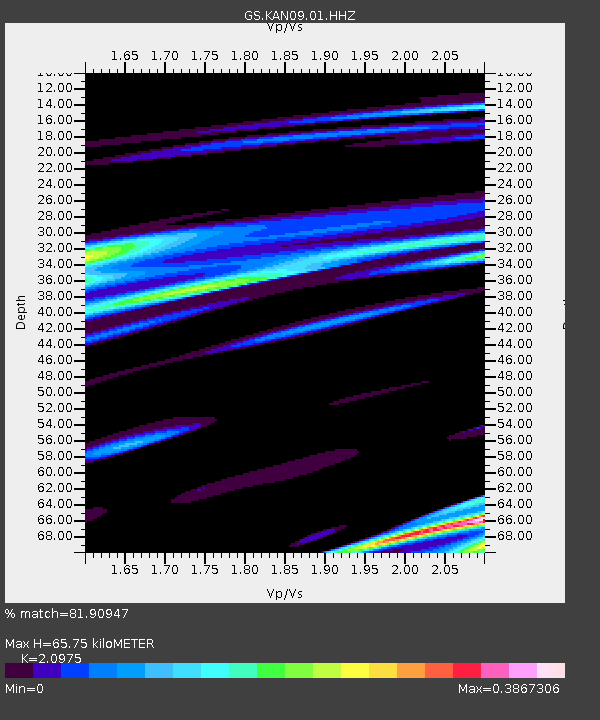
| Estimated Moho Depth: |
65.75 km |
| Estimated Crust Vp/Vs: |
2.10 |
| Assumed Crust Vp: |
6.483 km/s |
| Estimated Crust Vs: |
3.091 km/s |
| Estimated Crust Poisson's Ratio: |
0.35 |
|
| Radial Match: |
81.90947 % |
| Radial Bump: |
277 |
| Transverse Match: |
77.80483 % |
| Transverse Bump: |
244 |
| SOD ConfigId: |
820441 |
| Insert Time: |
2014-12-10 10:03:26.012 +0000 |
| GWidth: |
2.5 |
| Max Bumps: |
400 |
| Tol: |
0.001 |
|
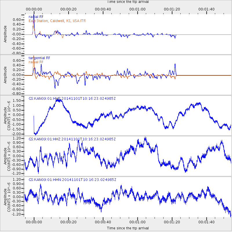
Signal To Noise
| Channel | StoN | STA | LTA |
| GS:KAN09:01:HHZ:20141101T10:16:23.024985Z | 1.8226998 | 5.13612E-7 | 2.8178638E-7 |
| GS:KAN09:01:HHN:20141101T10:16:23.024985Z | 0.7828754 | 4.035963E-7 | 5.155307E-7 |
| GS:KAN09:01:HHE:20141101T10:16:23.024985Z | 0.99142385 | 1.0879338E-6 | 1.0973448E-6 |
| Arrivals |
| Ps | 11 SECOND |
| PpPs | 30 SECOND |
| PsPs/PpSs | 42 SECOND |


