You are here: Home > Network List > TA - USArray Transportable Network (new EarthScope stations) Stations List
> Station G65A Princeton, ME, USA > Earthquake Result Viewer
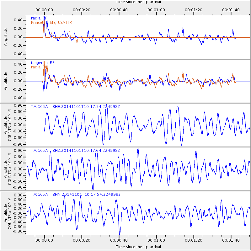
G65A Princeton, ME, USA - Earthquake Result Viewer
*The percent match for this event was below the threshold and hence no stack was calculated.
| Earthquake location: |
Easter Island Region |
| Earthquake latitude/longitude: |
-31.9/-111.1 |
| Earthquake time(UTC): |
2014/11/01 (305) 10:05:43 GMT |
| Earthquake Depth: |
10 km |
| Earthquake Magnitude: |
5.8 MWW, 5.6 MWB, 5.7 MWC |
| Earthquake Catalog/Contributor: |
NEIC PDE/NEIC COMCAT |
|
| Network: |
TA USArray Transportable Network (new EarthScope stations) |
| Station: |
G65A Princeton, ME, USA |
| Lat/Lon: |
45.20 N/67.56 W |
| Elevation: |
78 m |
|
| Distance: |
86.3 deg |
| Az: |
29.213 deg |
| Baz: |
215.946 deg |
| Ray Param: |
$rayparam |
*The percent match for this event was below the threshold and hence was not used in the summary stack. |
|
| Radial Match: |
55.610104 % |
| Radial Bump: |
400 |
| Transverse Match: |
48.752575 % |
| Transverse Bump: |
400 |
| SOD ConfigId: |
820441 |
| Insert Time: |
2014-12-10 10:17:09.132 +0000 |
| GWidth: |
2.5 |
| Max Bumps: |
400 |
| Tol: |
0.001 |
|
Signal To Noise
| Channel | StoN | STA | LTA |
| TA:G65A: :BHZ:20141101T10:17:54.224998Z | 0.84466904 | 4.0195826E-7 | 4.7587665E-7 |
| TA:G65A: :BHN:20141101T10:17:54.224998Z | 0.88831645 | 2.570938E-7 | 2.894169E-7 |
| TA:G65A: :BHE:20141101T10:17:54.224998Z | 1.8448542 | 6.1381064E-7 | 3.32715E-7 |
| Arrivals |
| Ps | |
| PpPs | |
| PsPs/PpSs | |


