You are here: Home > Network List > TA - USArray Transportable Network (new EarthScope stations) Stations List
> Station R59A King George, VA, USA > Earthquake Result Viewer
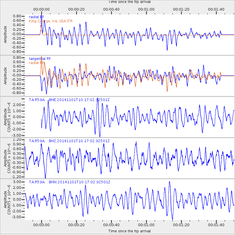
R59A King George, VA, USA - Earthquake Result Viewer
*The percent match for this event was below the threshold and hence no stack was calculated.
| Earthquake location: |
Easter Island Region |
| Earthquake latitude/longitude: |
-31.9/-111.1 |
| Earthquake time(UTC): |
2014/11/01 (305) 10:05:43 GMT |
| Earthquake Depth: |
10 km |
| Earthquake Magnitude: |
5.8 MWW, 5.6 MWB, 5.7 MWC |
| Earthquake Catalog/Contributor: |
NEIC PDE/NEIC COMCAT |
|
| Network: |
TA USArray Transportable Network (new EarthScope stations) |
| Station: |
R59A King George, VA, USA |
| Lat/Lon: |
38.20 N/77.12 W |
| Elevation: |
35 m |
|
| Distance: |
76.6 deg |
| Az: |
26.921 deg |
| Baz: |
209.254 deg |
| Ray Param: |
$rayparam |
*The percent match for this event was below the threshold and hence was not used in the summary stack. |
|
| Radial Match: |
50.844254 % |
| Radial Bump: |
396 |
| Transverse Match: |
52.782986 % |
| Transverse Bump: |
400 |
| SOD ConfigId: |
820441 |
| Insert Time: |
2014-12-10 10:19:59.029 +0000 |
| GWidth: |
2.5 |
| Max Bumps: |
400 |
| Tol: |
0.001 |
|
Signal To Noise
| Channel | StoN | STA | LTA |
| TA:R59A: :BHZ:20141101T10:17:02.92501Z | 1.9780337 | 6.338135E-7 | 3.2042604E-7 |
| TA:R59A: :BHN:20141101T10:17:02.92501Z | 0.5342404 | 5.205828E-7 | 9.744354E-7 |
| TA:R59A: :BHE:20141101T10:17:02.92501Z | 2.061378 | 1.9211354E-6 | 9.319666E-7 |
| Arrivals |
| Ps | |
| PpPs | |
| PsPs/PpSs | |


