You are here: Home > Network List > TA - USArray Transportable Network (new EarthScope stations) Stations List
> Station TUL1 Leonard, OK, USA > Earthquake Result Viewer
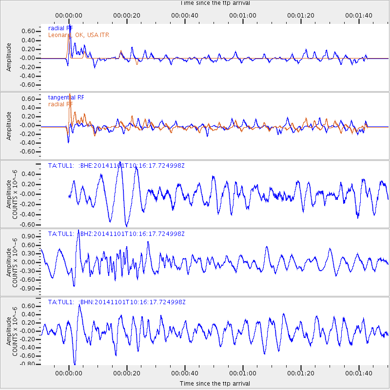
TUL1 Leonard, OK, USA - Earthquake Result Viewer
*The percent match for this event was below the threshold and hence no stack was calculated.
| Earthquake location: |
Easter Island Region |
| Earthquake latitude/longitude: |
-31.9/-111.1 |
| Earthquake time(UTC): |
2014/11/01 (305) 10:05:43 GMT |
| Earthquake Depth: |
10 km |
| Earthquake Magnitude: |
5.8 MWW, 5.6 MWB, 5.7 MWC |
| Earthquake Catalog/Contributor: |
NEIC PDE/NEIC COMCAT |
|
| Network: |
TA USArray Transportable Network (new EarthScope stations) |
| Station: |
TUL1 Leonard, OK, USA |
| Lat/Lon: |
35.91 N/95.79 W |
| Elevation: |
256 m |
|
| Distance: |
69.0 deg |
| Az: |
13.279 deg |
| Baz: |
193.922 deg |
| Ray Param: |
$rayparam |
*The percent match for this event was below the threshold and hence was not used in the summary stack. |
|
| Radial Match: |
64.72272 % |
| Radial Bump: |
400 |
| Transverse Match: |
52.833225 % |
| Transverse Bump: |
400 |
| SOD ConfigId: |
820441 |
| Insert Time: |
2014-12-10 10:20:53.723 +0000 |
| GWidth: |
2.5 |
| Max Bumps: |
400 |
| Tol: |
0.001 |
|
Signal To Noise
| Channel | StoN | STA | LTA |
| TA:TUL1: :BHZ:20141101T10:16:17.724998Z | 2.7595496 | 5.3623415E-7 | 1.9431944E-7 |
| TA:TUL1: :BHN:20141101T10:16:17.724998Z | 3.7658603 | 4.164964E-7 | 1.1059794E-7 |
| TA:TUL1: :BHE:20141101T10:16:17.724998Z | 0.22279671 | 6.734274E-8 | 3.0226093E-7 |
| Arrivals |
| Ps | |
| PpPs | |
| PsPs/PpSs | |


