You are here: Home > Network List > TA - USArray Transportable Network (new EarthScope stations) Stations List
> Station U56A King, NC, USA > Earthquake Result Viewer
U56A King, NC, USA - Earthquake Result Viewer
| Earthquake location: |
Easter Island Region |
| Earthquake latitude/longitude: |
-31.9/-111.1 |
| Earthquake time(UTC): |
2014/11/01 (305) 10:05:43 GMT |
| Earthquake Depth: |
10 km |
| Earthquake Magnitude: |
5.8 MWW, 5.6 MWB, 5.7 MWC |
| Earthquake Catalog/Contributor: |
NEIC PDE/NEIC COMCAT |
|
| Network: |
TA USArray Transportable Network (new EarthScope stations) |
| Station: |
U56A King, NC, USA |
| Lat/Lon: |
36.35 N/80.38 W |
| Elevation: |
363 m |
|
| Distance: |
73.8 deg |
| Az: |
25.443 deg |
| Baz: |
206.905 deg |
| Ray Param: |
0.052789904 |
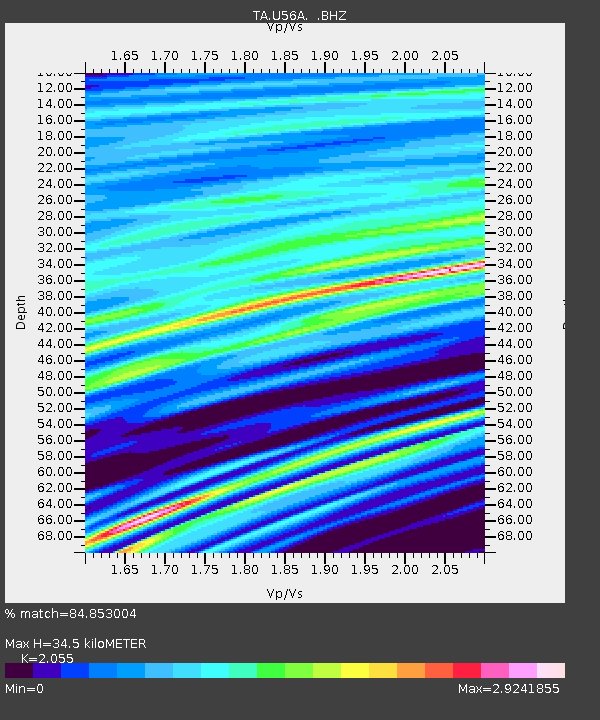
| Estimated Moho Depth: |
34.5 km |
| Estimated Crust Vp/Vs: |
2.06 |
| Assumed Crust Vp: |
6.159 km/s |
| Estimated Crust Vs: |
2.997 km/s |
| Estimated Crust Poisson's Ratio: |
0.34 |
|
| Radial Match: |
84.853004 % |
| Radial Bump: |
400 |
| Transverse Match: |
52.58371 % |
| Transverse Bump: |
400 |
| SOD ConfigId: |
820441 |
| Insert Time: |
2014-12-10 10:20:59.793 +0000 |
| GWidth: |
2.5 |
| Max Bumps: |
400 |
| Tol: |
0.001 |
|

Signal To Noise
| Channel | StoN | STA | LTA |
| TA:U56A: :BHZ:20141101T10:16:46.474998Z | 1.1269034 | 3.532013E-7 | 3.1342643E-7 |
| TA:U56A: :BHN:20141101T10:16:46.474998Z | 2.6260343 | 1.5055699E-6 | 5.7332454E-7 |
| TA:U56A: :BHE:20141101T10:16:46.474998Z | 0.7732197 | 3.6848806E-7 | 4.765632E-7 |
| Arrivals |
| Ps | 6.1 SECOND |
| PpPs | 17 SECOND |
| PsPs/PpSs | 23 SECOND |


