You are here: Home > Network List > US - United States National Seismic Network Stations List
> Station MNTX Cornudas Mountains, Texas, USA > Earthquake Result Viewer
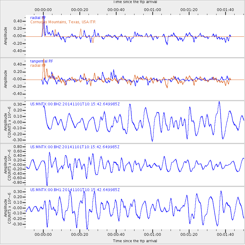
MNTX Cornudas Mountains, Texas, USA - Earthquake Result Viewer
*The percent match for this event was below the threshold and hence no stack was calculated.
| Earthquake location: |
Easter Island Region |
| Earthquake latitude/longitude: |
-31.9/-111.1 |
| Earthquake time(UTC): |
2014/11/01 (305) 10:05:43 GMT |
| Earthquake Depth: |
10 km |
| Earthquake Magnitude: |
5.8 MWW, 5.6 MWB, 5.7 MWC |
| Earthquake Catalog/Contributor: |
NEIC PDE/NEIC COMCAT |
|
| Network: |
US United States National Seismic Network |
| Station: |
MNTX Cornudas Mountains, Texas, USA |
| Lat/Lon: |
31.70 N/105.38 W |
| Elevation: |
404 m |
|
| Distance: |
63.5 deg |
| Az: |
5.452 deg |
| Baz: |
185.439 deg |
| Ray Param: |
$rayparam |
*The percent match for this event was below the threshold and hence was not used in the summary stack. |
|
| Radial Match: |
72.38878 % |
| Radial Bump: |
400 |
| Transverse Match: |
58.801838 % |
| Transverse Bump: |
342 |
| SOD ConfigId: |
820441 |
| Insert Time: |
2014-12-10 10:23:07.936 +0000 |
| GWidth: |
2.5 |
| Max Bumps: |
400 |
| Tol: |
0.001 |
|
Signal To Noise
| Channel | StoN | STA | LTA |
| US:MNTX:00:BHZ:20141101T10:15:42.649985Z | 2.3190215 | 3.970042E-7 | 1.7119469E-7 |
| US:MNTX:00:BH1:20141101T10:15:42.649985Z | 1.4856803 | 1.3920527E-7 | 9.369799E-8 |
| US:MNTX:00:BH2:20141101T10:15:42.649985Z | 1.191661 | 1.0728293E-7 | 9.002807E-8 |
| Arrivals |
| Ps | |
| PpPs | |
| PsPs/PpSs | |


