You are here: Home > Network List > YQ13 - Study of Extension and Magmatism in Malawi and Tanzania Stations List
> Station LOSI Makongolosi,Tanzania > Earthquake Result Viewer
LOSI Makongolosi,Tanzania - Earthquake Result Viewer
| Earthquake location: |
Nepal |
| Earthquake latitude/longitude: |
27.8/86.1 |
| Earthquake time(UTC): |
2015/05/12 (132) 07:05:19 GMT |
| Earthquake Depth: |
15 km |
| Earthquake Magnitude: |
7.3 MWW |
| Earthquake Catalog/Contributor: |
NEIC PDE/NEIC COMCAT |
|
| Network: |
YQ Study of Extension and Magmatism in Malawi and Tanzania |
| Station: |
LOSI Makongolosi,Tanzania |
| Lat/Lon: |
8.39 S/33.17 E |
| Elevation: |
1233 m |
|
| Distance: |
62.5 deg |
| Az: |
242.807 deg |
| Baz: |
52.759 deg |
| Ray Param: |
0.060147446 |
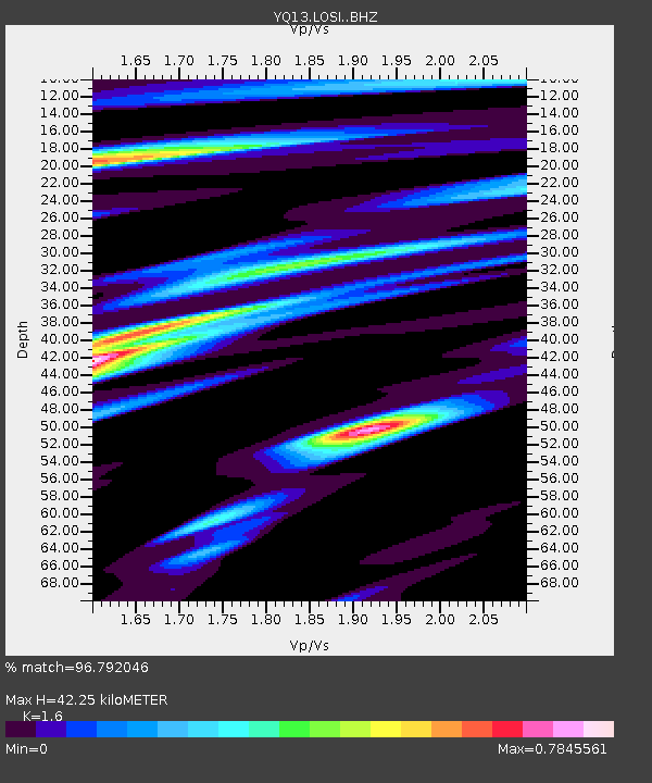
| Estimated Moho Depth: |
42.25 km |
| Estimated Crust Vp/Vs: |
1.60 |
| Assumed Crust Vp: |
6.502 km/s |
| Estimated Crust Vs: |
4.063 km/s |
| Estimated Crust Poisson's Ratio: |
0.18 |
|
| Radial Match: |
96.792046 % |
| Radial Bump: |
351 |
| Transverse Match: |
90.298874 % |
| Transverse Bump: |
381 |
| SOD ConfigId: |
7422571 |
| Insert Time: |
2019-04-18 20:14:14.515 +0000 |
| GWidth: |
2.5 |
| Max Bumps: |
400 |
| Tol: |
0.001 |
|

Signal To Noise
| Channel | StoN | STA | LTA |
| YQ:LOSI: :BHZ:20150512T07:15:11.334993Z | 14.59952 | 1.3329709E-6 | 9.1302375E-8 |
| YQ:LOSI: :BHN:20150512T07:15:11.334993Z | 4.82465 | 6.13448E-7 | 1.2714871E-7 |
| YQ:LOSI: :BHE:20150512T07:15:11.334993Z | 1.7868872 | 6.3145006E-7 | 3.5337993E-7 |
| Arrivals |
| Ps | 4.1 SECOND |
| PpPs | 16 SECOND |
| PsPs/PpSs | 20 SECOND |


