You are here: Home > Network List > AK - Alaska Regional Network Stations List
> Station BWN Brown > Earthquake Result Viewer
BWN Brown - Earthquake Result Viewer
| Earthquake location: |
Northern Molucca Sea |
| Earthquake latitude/longitude: |
1.9/126.5 |
| Earthquake time(UTC): |
2014/11/26 (330) 14:33:43 GMT |
| Earthquake Depth: |
39 km |
| Earthquake Magnitude: |
6.8 MWW, 6.8 MWC, 6.8 MWB, 7.0 MI |
| Earthquake Catalog/Contributor: |
NEIC PDE/NEIC COMCAT |
|
| Network: |
AK Alaska Regional Network |
| Station: |
BWN Brown |
| Lat/Lon: |
64.17 N/149.30 W |
| Elevation: |
369 m |
|
| Distance: |
85.7 deg |
| Az: |
25.911 deg |
| Baz: |
265.594 deg |
| Ray Param: |
0.044496045 |
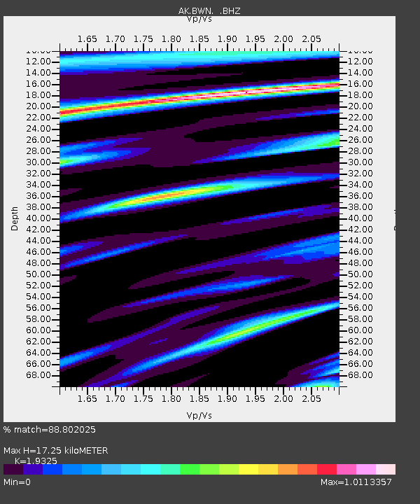
| Estimated Moho Depth: |
17.25 km |
| Estimated Crust Vp/Vs: |
1.93 |
| Assumed Crust Vp: |
6.566 km/s |
| Estimated Crust Vs: |
3.398 km/s |
| Estimated Crust Poisson's Ratio: |
0.32 |
|
| Radial Match: |
88.802025 % |
| Radial Bump: |
400 |
| Transverse Match: |
78.07109 % |
| Transverse Bump: |
400 |
| SOD ConfigId: |
820627 |
| Insert Time: |
2014-12-10 14:49:33.235 +0000 |
| GWidth: |
2.5 |
| Max Bumps: |
400 |
| Tol: |
0.001 |
|

Signal To Noise
| Channel | StoN | STA | LTA |
| AK:BWN: :BHZ:20141126T14:45:47.407974Z | 26.46778 | 3.4298973E-6 | 1.2958765E-7 |
| AK:BWN: :BHN:20141126T14:45:47.407974Z | 0.64691013 | 3.0699343E-7 | 4.7455345E-7 |
| AK:BWN: :BHE:20141126T14:45:47.407974Z | 2.1043463 | 9.493736E-7 | 4.5114894E-7 |
| Arrivals |
| Ps | 2.5 SECOND |
| PpPs | 7.5 SECOND |
| PsPs/PpSs | 10 SECOND |


