You are here: Home > Network List > ZV14 - Southern Lake Tanganyika experiment Stations List
> Station LAEA LAELA > Earthquake Result Viewer
LAEA LAELA - Earthquake Result Viewer
| Earthquake location: |
Nepal |
| Earthquake latitude/longitude: |
27.8/86.1 |
| Earthquake time(UTC): |
2015/05/12 (132) 07:05:19 GMT |
| Earthquake Depth: |
15 km |
| Earthquake Magnitude: |
7.3 MWW |
| Earthquake Catalog/Contributor: |
NEIC PDE/NEIC COMCAT |
|
| Network: |
ZV Southern Lake Tanganyika experiment |
| Station: |
LAEA LAELA |
| Lat/Lon: |
8.58 S/32.04 E |
| Elevation: |
1568 m |
|
| Distance: |
63.5 deg |
| Az: |
243.391 deg |
| Baz: |
53.188 deg |
| Ray Param: |
0.059498336 |
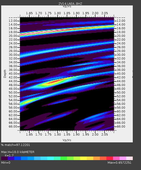
| Estimated Moho Depth: |
18.0 km |
| Estimated Crust Vp/Vs: |
1.70 |
| Assumed Crust Vp: |
6.502 km/s |
| Estimated Crust Vs: |
3.824 km/s |
| Estimated Crust Poisson's Ratio: |
0.24 |
|
| Radial Match: |
97.12201 % |
| Radial Bump: |
183 |
| Transverse Match: |
90.24274 % |
| Transverse Bump: |
340 |
| SOD ConfigId: |
7422571 |
| Insert Time: |
2019-04-18 20:14:40.750 +0000 |
| GWidth: |
2.5 |
| Max Bumps: |
400 |
| Tol: |
0.001 |
|

Signal To Noise
| Channel | StoN | STA | LTA |
| ZV:LAEA: :BHZ:20150512T07:15:17.980012Z | 12.200489 | 1.0004377E-6 | 8.199981E-8 |
| ZV:LAEA: :BHN:20150512T07:15:17.980012Z | 5.2190847 | 2.729466E-7 | 5.2297793E-8 |
| ZV:LAEA: :BHE:20150512T07:15:17.980012Z | 6.4835205 | 3.4725895E-7 | 5.3560242E-8 |
| Arrivals |
| Ps | 2.0 SECOND |
| PpPs | 7.1 SECOND |
| PsPs/PpSs | 9.2 SECOND |


