You are here: Home > Network List > AK - Alaska Regional Network Stations List
> Station ISLE Juniper Island, AK, USA > Earthquake Result Viewer
ISLE Juniper Island, AK, USA - Earthquake Result Viewer
| Earthquake location: |
Northern Molucca Sea |
| Earthquake latitude/longitude: |
1.9/126.5 |
| Earthquake time(UTC): |
2014/11/26 (330) 14:33:43 GMT |
| Earthquake Depth: |
39 km |
| Earthquake Magnitude: |
6.8 MWW, 6.8 MWC, 6.8 MWB, 7.0 MI |
| Earthquake Catalog/Contributor: |
NEIC PDE/NEIC COMCAT |
|
| Network: |
AK Alaska Regional Network |
| Station: |
ISLE Juniper Island, AK, USA |
| Lat/Lon: |
60.60 N/142.34 W |
| Elevation: |
1485 m |
|
| Distance: |
88.9 deg |
| Az: |
29.563 deg |
| Baz: |
271.924 deg |
| Ray Param: |
0.042191237 |
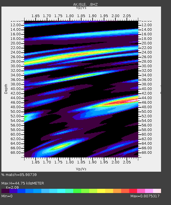
| Estimated Moho Depth: |
44.75 km |
| Estimated Crust Vp/Vs: |
2.09 |
| Assumed Crust Vp: |
6.566 km/s |
| Estimated Crust Vs: |
3.142 km/s |
| Estimated Crust Poisson's Ratio: |
0.35 |
|
| Radial Match: |
85.98739 % |
| Radial Bump: |
400 |
| Transverse Match: |
73.02025 % |
| Transverse Bump: |
400 |
| SOD ConfigId: |
820627 |
| Insert Time: |
2014-12-10 14:50:46.577 +0000 |
| GWidth: |
2.5 |
| Max Bumps: |
400 |
| Tol: |
0.001 |
|

Signal To Noise
| Channel | StoN | STA | LTA |
| AK:ISLE: :BHZ:20141126T14:46:02.628005Z | 13.927025 | 1.7525393E-6 | 1.258373E-7 |
| AK:ISLE: :BHN:20141126T14:46:02.628005Z | 0.712006 | 2.514438E-7 | 3.5314844E-7 |
| AK:ISLE: :BHE:20141126T14:46:02.628005Z | 4.8643317 | 8.124759E-7 | 1.6702724E-7 |
| Arrivals |
| Ps | 7.6 SECOND |
| PpPs | 21 SECOND |
| PsPs/PpSs | 28 SECOND |


