You are here: Home > Network List > AK - Alaska Regional Network Stations List
> Station WAT2 Susitna Watana 2, AK, USA > Earthquake Result Viewer
WAT2 Susitna Watana 2, AK, USA - Earthquake Result Viewer
| Earthquake location: |
Northern Molucca Sea |
| Earthquake latitude/longitude: |
1.9/126.5 |
| Earthquake time(UTC): |
2014/11/26 (330) 14:33:43 GMT |
| Earthquake Depth: |
39 km |
| Earthquake Magnitude: |
6.8 MWW, 6.8 MWC, 6.8 MWB, 7.0 MI |
| Earthquake Catalog/Contributor: |
NEIC PDE/NEIC COMCAT |
|
| Network: |
AK Alaska Regional Network |
| Station: |
WAT2 Susitna Watana 2, AK, USA |
| Lat/Lon: |
62.96 N/148.59 W |
| Elevation: |
1366 m |
|
| Distance: |
86.0 deg |
| Az: |
27.149 deg |
| Baz: |
266.319 deg |
| Ray Param: |
0.044331957 |
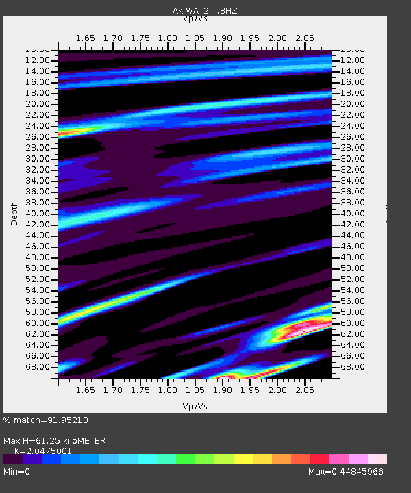
| Estimated Moho Depth: |
61.25 km |
| Estimated Crust Vp/Vs: |
2.05 |
| Assumed Crust Vp: |
6.566 km/s |
| Estimated Crust Vs: |
3.207 km/s |
| Estimated Crust Poisson's Ratio: |
0.34 |
|
| Radial Match: |
91.95218 % |
| Radial Bump: |
400 |
| Transverse Match: |
82.322754 % |
| Transverse Bump: |
400 |
| SOD ConfigId: |
820627 |
| Insert Time: |
2014-12-10 14:52:31.561 +0000 |
| GWidth: |
2.5 |
| Max Bumps: |
400 |
| Tol: |
0.001 |
|

Signal To Noise
| Channel | StoN | STA | LTA |
| AK:WAT2: :BHZ:20141126T14:45:48.568008Z | 17.471815 | 3.2817263E-6 | 1.8782973E-7 |
| AK:WAT2: :BHN:20141126T14:45:48.568008Z | 1.6088123 | 2.8770668E-7 | 1.7883173E-7 |
| AK:WAT2: :BHE:20141126T14:45:48.568008Z | 6.1218734 | 1.3222059E-6 | 2.159806E-7 |
| Arrivals |
| Ps | 10.0 SECOND |
| PpPs | 28 SECOND |
| PsPs/PpSs | 38 SECOND |


