You are here: Home > Network List > IU - Global Seismograph Network (GSN - IRIS/USGS) Stations List
> Station POHA Pohakuloa, Hawaii, USA > Earthquake Result Viewer
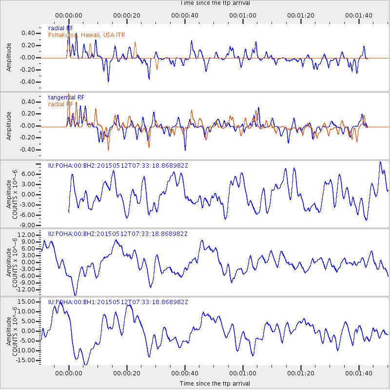
POHA Pohakuloa, Hawaii, USA - Earthquake Result Viewer
*The percent match for this event was below the threshold and hence no stack was calculated.
| Earthquake location: |
Banda Sea |
| Earthquake latitude/longitude: |
-7.3/129.2 |
| Earthquake time(UTC): |
2015/05/12 (132) 07:22:04 GMT |
| Earthquake Depth: |
150 km |
| Earthquake Magnitude: |
5.2 mb, 5.1 mb |
| Earthquake Catalog/Contributor: |
ISC/ISC |
|
| Network: |
IU Global Seismograph Network (GSN - IRIS/USGS) |
| Station: |
POHA Pohakuloa, Hawaii, USA |
| Lat/Lon: |
19.76 N/155.53 W |
| Elevation: |
1990 m |
|
| Distance: |
78.7 deg |
| Az: |
68.238 deg |
| Baz: |
258.033 deg |
| Ray Param: |
$rayparam |
*The percent match for this event was below the threshold and hence was not used in the summary stack. |
|
| Radial Match: |
78.747444 % |
| Radial Bump: |
400 |
| Transverse Match: |
83.20882 % |
| Transverse Bump: |
384 |
| SOD ConfigId: |
7422571 |
| Insert Time: |
2019-04-18 20:19:13.788 +0000 |
| GWidth: |
2.5 |
| Max Bumps: |
400 |
| Tol: |
0.001 |
|
Signal To Noise
| Channel | StoN | STA | LTA |
| IU:POHA:00:BHZ:20150512T07:33:18.868982Z | 1.4935818 | 8.909851E-6 | 5.9654258E-6 |
| IU:POHA:00:BH1:20150512T07:33:18.868982Z | 2.0535343 | 1.0052088E-5 | 4.8950183E-6 |
| IU:POHA:00:BH2:20150512T07:33:18.868982Z | 0.91171557 | 2.818064E-6 | 3.0909464E-6 |
| Arrivals |
| Ps | |
| PpPs | |
| PsPs/PpSs | |


