You are here: Home > Network List > AU - Australian Seismological Centre Stations List
> Station LHI Lord Howe Island, Australia > Earthquake Result Viewer
LHI Lord Howe Island, Australia - Earthquake Result Viewer
| Earthquake location: |
Northern Molucca Sea |
| Earthquake latitude/longitude: |
1.9/126.5 |
| Earthquake time(UTC): |
2014/11/26 (330) 14:33:43 GMT |
| Earthquake Depth: |
39 km |
| Earthquake Magnitude: |
6.8 MWW, 6.8 MWC, 6.8 MWB, 7.0 MI |
| Earthquake Catalog/Contributor: |
NEIC PDE/NEIC COMCAT |
|
| Network: |
AU Australian Seismological Centre |
| Station: |
LHI Lord Howe Island, Australia |
| Lat/Lon: |
31.52 S/159.06 E |
| Elevation: |
74 m |
|
| Distance: |
45.4 deg |
| Az: |
139.826 deg |
| Baz: |
310.978 deg |
| Ray Param: |
0.07121924 |
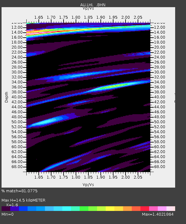
| Estimated Moho Depth: |
14.5 km |
| Estimated Crust Vp/Vs: |
1.60 |
| Assumed Crust Vp: |
4.157 km/s |
| Estimated Crust Vs: |
2.598 km/s |
| Estimated Crust Poisson's Ratio: |
0.18 |
|
| Radial Match: |
81.0775 % |
| Radial Bump: |
375 |
| Transverse Match: |
54.770058 % |
| Transverse Bump: |
400 |
| SOD ConfigId: |
820627 |
| Insert Time: |
2014-12-10 14:53:53.088 +0000 |
| GWidth: |
2.5 |
| Max Bumps: |
400 |
| Tol: |
0.001 |
|

Signal To Noise
| Channel | StoN | STA | LTA |
| AU:LHI: :BHZ:20141126T14:41:27.79399Z | 3.2761483 | 3.4373713E-6 | 1.049211E-6 |
| AU:LHI: :BHN:20141126T14:41:27.79399Z | 2.1354523 | 1.7530455E-6 | 8.209247E-7 |
| AU:LHI: :BHE:20141126T14:41:27.79399Z | 1.512272 | 1.5338895E-6 | 1.0142948E-6 |
| Arrivals |
| Ps | 2.2 SECOND |
| PpPs | 8.8 SECOND |
| PsPs/PpSs | 11 SECOND |


