You are here: Home > Network List > PS - Pacific21 Stations List
> Station PATS 6onpei, Micronesia > Earthquake Result Viewer
PATS 6onpei, Micronesia - Earthquake Result Viewer
| Earthquake location: |
Northern Molucca Sea |
| Earthquake latitude/longitude: |
1.9/126.5 |
| Earthquake time(UTC): |
2014/11/26 (330) 14:33:43 GMT |
| Earthquake Depth: |
39 km |
| Earthquake Magnitude: |
6.8 MWW, 6.8 MWC, 6.8 MWB, 7.0 MI |
| Earthquake Catalog/Contributor: |
NEIC PDE/NEIC COMCAT |
|
| Network: |
PS Pacific21 |
| Station: |
PATS 6onpei, Micronesia |
| Lat/Lon: |
6.84 N/158.32 E |
| Elevation: |
10 m |
|
| Distance: |
32.1 deg |
| Az: |
80.231 deg |
| Baz: |
262.708 deg |
| Ray Param: |
0.0787477 |
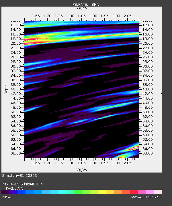
| Estimated Moho Depth: |
65.5 km |
| Estimated Crust Vp/Vs: |
2.08 |
| Assumed Crust Vp: |
4.24 km/s |
| Estimated Crust Vs: |
2.041 km/s |
| Estimated Crust Poisson's Ratio: |
0.35 |
|
| Radial Match: |
81.20803 % |
| Radial Bump: |
400 |
| Transverse Match: |
64.76773 % |
| Transverse Bump: |
400 |
| SOD ConfigId: |
820627 |
| Insert Time: |
2014-12-10 15:01:18.447 +0000 |
| GWidth: |
2.5 |
| Max Bumps: |
400 |
| Tol: |
0.001 |
|
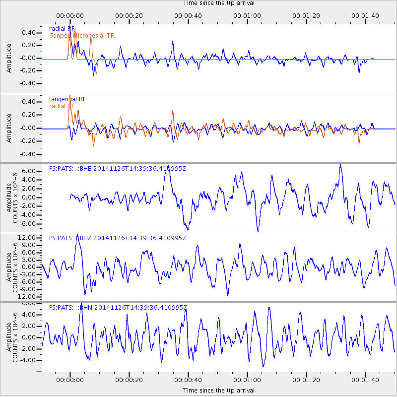
Signal To Noise
| Channel | StoN | STA | LTA |
| PS:PATS: :BHZ:20141126T14:39:36.410995Z | 4.373872 | 6.8571944E-6 | 1.567763E-6 |
| PS:PATS: :BHN:20141126T14:39:36.410995Z | 2.051839 | 2.394123E-6 | 1.166818E-6 |
| PS:PATS: :BHE:20141126T14:39:36.410995Z | 4.876421 | 4.042439E-6 | 8.2897657E-7 |
| Arrivals |
| Ps | 17 SECOND |
| PpPs | 46 SECOND |
| PsPs/PpSs | 63 SECOND |


