You are here: Home > Network List > S - Seismographs in Schools Projects Stations List
> Station AUKAL John Paul College, Kalgoorlie, WA > Earthquake Result Viewer
AUKAL John Paul College, Kalgoorlie, WA - Earthquake Result Viewer
| Earthquake location: |
Northern Molucca Sea |
| Earthquake latitude/longitude: |
1.9/126.5 |
| Earthquake time(UTC): |
2014/11/26 (330) 14:33:43 GMT |
| Earthquake Depth: |
39 km |
| Earthquake Magnitude: |
6.8 MWW, 6.8 MWC, 6.8 MWB, 7.0 MI |
| Earthquake Catalog/Contributor: |
NEIC PDE/NEIC COMCAT |
|
| Network: |
S Seismographs in Schools Projects |
| Station: |
AUKAL John Paul College, Kalgoorlie, WA |
| Lat/Lon: |
30.76 S/121.48 E |
| Elevation: |
373 m |
|
| Distance: |
32.9 deg |
| Az: |
188.03 deg |
| Baz: |
9.334 deg |
| Ray Param: |
0.07840266 |
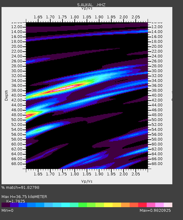
| Estimated Moho Depth: |
36.75 km |
| Estimated Crust Vp/Vs: |
1.76 |
| Assumed Crust Vp: |
6.459 km/s |
| Estimated Crust Vs: |
3.665 km/s |
| Estimated Crust Poisson's Ratio: |
0.26 |
|
| Radial Match: |
91.82798 % |
| Radial Bump: |
239 |
| Transverse Match: |
61.685707 % |
| Transverse Bump: |
400 |
| SOD ConfigId: |
820627 |
| Insert Time: |
2014-12-10 15:01:55.621 +0000 |
| GWidth: |
2.5 |
| Max Bumps: |
400 |
| Tol: |
0.001 |
|

Signal To Noise
| Channel | StoN | STA | LTA |
| S:AUKAL: :HHZ:20141126T14:39:43.430007Z | 5.529072 | 8.481046E-6 | 1.5339004E-6 |
| S:AUKAL: :HHN:20141126T14:39:43.430007Z | 3.691046 | 4.586348E-6 | 1.2425605E-6 |
| S:AUKAL: :HHE:20141126T14:39:43.430007Z | 1.0198923 | 2.2132774E-6 | 2.1701087E-6 |
| Arrivals |
| Ps | 4.7 SECOND |
| PpPs | 15 SECOND |
| PsPs/PpSs | 19 SECOND |


