You are here: Home > Network List > S - Seismographs in Schools Projects Stations List
> Station AUMHS Melrose High School, ACT > Earthquake Result Viewer
AUMHS Melrose High School, ACT - Earthquake Result Viewer
| Earthquake location: |
Northern Molucca Sea |
| Earthquake latitude/longitude: |
1.9/126.5 |
| Earthquake time(UTC): |
2014/11/26 (330) 14:33:43 GMT |
| Earthquake Depth: |
39 km |
| Earthquake Magnitude: |
6.8 MWW, 6.8 MWC, 6.8 MWB, 7.0 MI |
| Earthquake Catalog/Contributor: |
NEIC PDE/NEIC COMCAT |
|
| Network: |
S Seismographs in Schools Projects |
| Station: |
AUMHS Melrose High School, ACT |
| Lat/Lon: |
35.36 S/149.09 E |
| Elevation: |
615 m |
|
| Distance: |
42.7 deg |
| Az: |
152.449 deg |
| Baz: |
325.556 deg |
| Ray Param: |
0.072944805 |
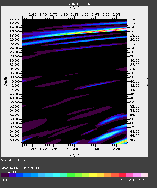
| Estimated Moho Depth: |
14.75 km |
| Estimated Crust Vp/Vs: |
2.09 |
| Assumed Crust Vp: |
6.633 km/s |
| Estimated Crust Vs: |
3.181 km/s |
| Estimated Crust Poisson's Ratio: |
0.35 |
|
| Radial Match: |
87.9888 % |
| Radial Bump: |
400 |
| Transverse Match: |
57.588394 % |
| Transverse Bump: |
400 |
| SOD ConfigId: |
820627 |
| Insert Time: |
2014-12-10 15:02:16.698 +0000 |
| GWidth: |
2.5 |
| Max Bumps: |
400 |
| Tol: |
0.001 |
|

Signal To Noise
| Channel | StoN | STA | LTA |
| S:AUMHS: :HHZ:20141126T14:41:06.110Z | 7.4024143 | 7.3617057E-6 | 9.945006E-7 |
| S:AUMHS: :HHN:20141126T14:41:06.110Z | 4.138372 | 5.186405E-6 | 1.2532477E-6 |
| S:AUMHS: :HHE:20141126T14:41:06.110Z | 0.72206974 | 2.23825E-6 | 3.0997699E-6 |
| Arrivals |
| Ps | 2.6 SECOND |
| PpPs | 6.5 SECOND |
| PsPs/PpSs | 9.0 SECOND |


