You are here: Home > Network List > AV - Alaska Volcano Observatory Stations List
> Station MAPS Pakushin Southeast, Makushin Volcano, Alaska > Earthquake Result Viewer
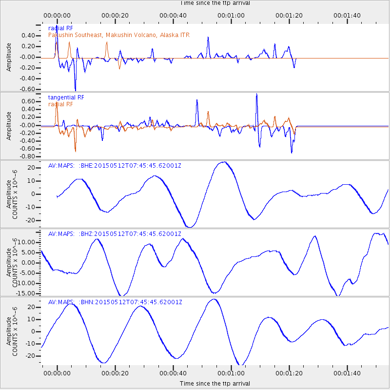
MAPS Pakushin Southeast, Makushin Volcano, Alaska - Earthquake Result Viewer
*The percent match for this event was below the threshold and hence no stack was calculated.
| Earthquake location: |
Nepal |
| Earthquake latitude/longitude: |
27.7/86.2 |
| Earthquake time(UTC): |
2015/05/12 (132) 07:34:22 GMT |
| Earthquake Depth: |
11 km |
| Earthquake Magnitude: |
5.4 mb, 5.3 mb |
| Earthquake Catalog/Contributor: |
ISC/ISC |
|
| Network: |
AV Alaska Volcano Observatory |
| Station: |
MAPS Pakushin Southeast, Makushin Volcano, Alaska |
| Lat/Lon: |
53.81 N/166.94 W |
| Elevation: |
333 m |
|
| Distance: |
77.3 deg |
| Az: |
35.585 deg |
| Baz: |
299.537 deg |
| Ray Param: |
$rayparam |
*The percent match for this event was below the threshold and hence was not used in the summary stack. |
|
| Radial Match: |
71.789024 % |
| Radial Bump: |
400 |
| Transverse Match: |
45.575733 % |
| Transverse Bump: |
196 |
| SOD ConfigId: |
7422571 |
| Insert Time: |
2019-04-18 20:21:50.278 +0000 |
| GWidth: |
2.5 |
| Max Bumps: |
400 |
| Tol: |
0.001 |
|
Signal To Noise
| Channel | StoN | STA | LTA |
| AV:MAPS: :BHZ:20150512T07:45:45.62001Z | 1.2948684 | 4.570901E-6 | 3.530012E-6 |
| AV:MAPS: :BHN:20150512T07:45:45.62001Z | 1.9261699 | 1.9748459E-5 | 1.0252709E-5 |
| AV:MAPS: :BHE:20150512T07:45:45.62001Z | 1.5166502 | 1.2460583E-5 | 8.215858E-6 |
| Arrivals |
| Ps | |
| PpPs | |
| PsPs/PpSs | |


