You are here: Home > Network List > TA - USArray Transportable Network (new EarthScope stations) Stations List
> Station K27K Chicken, AK, USA > Earthquake Result Viewer
K27K Chicken, AK, USA - Earthquake Result Viewer
| Earthquake location: |
Northern Molucca Sea |
| Earthquake latitude/longitude: |
1.9/126.5 |
| Earthquake time(UTC): |
2014/11/26 (330) 14:33:43 GMT |
| Earthquake Depth: |
39 km |
| Earthquake Magnitude: |
6.8 MWW, 6.8 MWC, 6.8 MWB, 7.0 MI |
| Earthquake Catalog/Contributor: |
NEIC PDE/NEIC COMCAT |
|
| Network: |
TA USArray Transportable Network (new EarthScope stations) |
| Station: |
K27K Chicken, AK, USA |
| Lat/Lon: |
64.03 N/142.08 W |
| Elevation: |
389 m |
|
| Distance: |
88.9 deg |
| Az: |
26.12 deg |
| Baz: |
272.092 deg |
| Ray Param: |
0.042188834 |
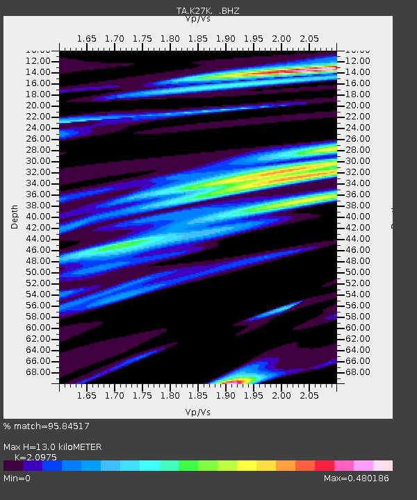
| Estimated Moho Depth: |
13.0 km |
| Estimated Crust Vp/Vs: |
2.10 |
| Assumed Crust Vp: |
6.566 km/s |
| Estimated Crust Vs: |
3.13 km/s |
| Estimated Crust Poisson's Ratio: |
0.35 |
|
| Radial Match: |
95.84517 % |
| Radial Bump: |
400 |
| Transverse Match: |
83.34158 % |
| Transverse Bump: |
400 |
| SOD ConfigId: |
820627 |
| Insert Time: |
2014-12-10 15:03:15.486 +0000 |
| GWidth: |
2.5 |
| Max Bumps: |
400 |
| Tol: |
0.001 |
|

Signal To Noise
| Channel | StoN | STA | LTA |
| TA:K27K: :BHZ:20141126T14:46:02.649978Z | 6.183531 | 1.1347598E-6 | 1.8351325E-7 |
| TA:K27K: :BHN:20141126T14:46:02.649978Z | 0.86054695 | 1.6562882E-7 | 1.9246926E-7 |
| TA:K27K: :BHE:20141126T14:46:02.649978Z | 2.7209408 | 3.6117564E-7 | 1.3273925E-7 |
| Arrivals |
| Ps | 2.2 SECOND |
| PpPs | 6.0 SECOND |
| PsPs/PpSs | 8.2 SECOND |


