You are here: Home > Network List > TA - USArray Transportable Network (new EarthScope stations) Stations List
> Station A21K Barrow, AK, USA > Earthquake Result Viewer
A21K Barrow, AK, USA - Earthquake Result Viewer
| Earthquake location: |
Nepal |
| Earthquake latitude/longitude: |
27.7/86.2 |
| Earthquake time(UTC): |
2015/05/12 (132) 07:34:22 GMT |
| Earthquake Depth: |
11 km |
| Earthquake Magnitude: |
5.4 mb, 5.3 mb |
| Earthquake Catalog/Contributor: |
ISC/ISC |
|
| Network: |
TA USArray Transportable Network (new EarthScope stations) |
| Station: |
A21K Barrow, AK, USA |
| Lat/Lon: |
71.32 N/156.62 W |
| Elevation: |
577 m |
|
| Distance: |
72.1 deg |
| Az: |
17.532 deg |
| Baz: |
303.995 deg |
| Ray Param: |
0.053879537 |
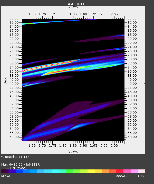
| Estimated Moho Depth: |
35.25 km |
| Estimated Crust Vp/Vs: |
1.61 |
| Assumed Crust Vp: |
6.048 km/s |
| Estimated Crust Vs: |
3.751 km/s |
| Estimated Crust Poisson's Ratio: |
0.19 |
|
| Radial Match: |
83.83711 % |
| Radial Bump: |
400 |
| Transverse Match: |
22.500427 % |
| Transverse Bump: |
315 |
| SOD ConfigId: |
7422571 |
| Insert Time: |
2019-04-18 20:23:31.974 +0000 |
| GWidth: |
2.5 |
| Max Bumps: |
400 |
| Tol: |
0.001 |
|

Signal To Noise
| Channel | StoN | STA | LTA |
| TA:A21K: :BHZ:20150512T07:45:15.625015Z | 2.09907 | 1.580121E-5 | 7.5277185E-6 |
| TA:A21K: :BHN:20150512T07:45:15.625015Z | 2.5536637 | 1.6715416E-5 | 6.5456607E-6 |
| TA:A21K: :BHE:20150512T07:45:15.625015Z | 1.2264388 | 1.5065452E-5 | 1.2283901E-5 |
| Arrivals |
| Ps | 3.7 SECOND |
| PpPs | 15 SECOND |
| PsPs/PpSs | 18 SECOND |


