You are here: Home > Network List > AV - Alaska Volcano Observatory Stations List
> Station MAPS Pakushin Southeast, Makushin Volcano, Alaska > Earthquake Result Viewer
MAPS Pakushin Southeast, Makushin Volcano, Alaska - Earthquake Result Viewer
| Earthquake location: |
Nepal |
| Earthquake latitude/longitude: |
27.6/86.2 |
| Earthquake time(UTC): |
2015/05/12 (132) 07:36:53 GMT |
| Earthquake Depth: |
15 km |
| Earthquake Magnitude: |
6.3 MB |
| Earthquake Catalog/Contributor: |
NEIC PDE/NEIC COMCAT |
|
| Network: |
AV Alaska Volcano Observatory |
| Station: |
MAPS Pakushin Southeast, Makushin Volcano, Alaska |
| Lat/Lon: |
53.81 N/166.94 W |
| Elevation: |
333 m |
|
| Distance: |
77.4 deg |
| Az: |
35.557 deg |
| Baz: |
299.537 deg |
| Ray Param: |
0.050347615 |
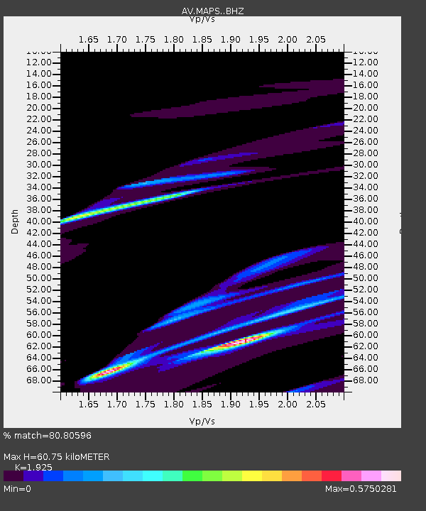
| Estimated Moho Depth: |
60.75 km |
| Estimated Crust Vp/Vs: |
1.92 |
| Assumed Crust Vp: |
3.943 km/s |
| Estimated Crust Vs: |
2.049 km/s |
| Estimated Crust Poisson's Ratio: |
0.32 |
|
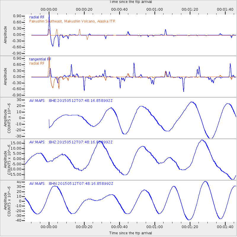
| Radial Match: |
80.80596 % |
| Radial Bump: |
238 |
| Transverse Match: |
47.0681 % |
| Transverse Bump: |
150 |
| SOD ConfigId: |
7422571 |
| Insert Time: |
2019-04-18 20:25:07.295 +0000 |
| GWidth: |
2.5 |
| Max Bumps: |
400 |
| Tol: |
0.001 |
|
Signal To Noise
| Channel | StoN | STA | LTA |
| AV:MAPS: :BHZ:20150512T07:48:16.858992Z | 0.33765766 | 1.5465943E-6 | 4.5803617E-6 |
| AV:MAPS: :BHN:20150512T07:48:16.858992Z | 2.7108133 | 2.9503268E-5 | 1.0883548E-5 |
| AV:MAPS: :BHE:20150512T07:48:16.858992Z | 1.6087302 | 1.0674873E-5 | 6.635589E-6 |
| Arrivals |
| Ps | 14 SECOND |
| PpPs | 45 SECOND |
| PsPs/PpSs | 59 SECOND |


