You are here: Home > Network List > TA - USArray Transportable Network (new EarthScope stations) Stations List
> Station H17A Grant Village (NPS), Yellowstone Nt. Park, WY, USA > Earthquake Result Viewer
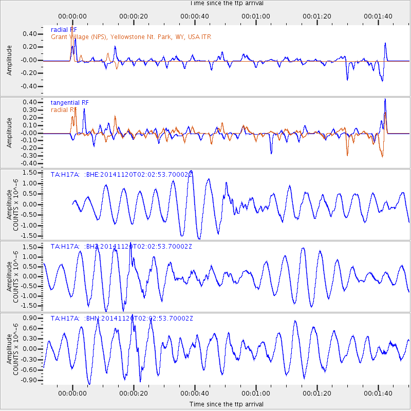
H17A Grant Village (NPS), Yellowstone Nt. Park, WY, USA - Earthquake Result Viewer
*The percent match for this event was below the threshold and hence no stack was calculated.
| Earthquake location: |
Near East Coast Of Honshu, Japan |
| Earthquake latitude/longitude: |
37.3/141.6 |
| Earthquake time(UTC): |
2014/11/20 (324) 01:51:42 GMT |
| Earthquake Depth: |
32 km |
| Earthquake Magnitude: |
5.6 MWW, 5.5 MWB, 5.5 MWR, 5.6 MWC |
| Earthquake Catalog/Contributor: |
NEIC PDE/NEIC COMCAT |
|
| Network: |
TA USArray Transportable Network (new EarthScope stations) |
| Station: |
H17A Grant Village (NPS), Yellowstone Nt. Park, WY, USA |
| Lat/Lon: |
44.40 N/110.58 W |
| Elevation: |
2400 m |
|
| Distance: |
75.8 deg |
| Az: |
44.76 deg |
| Baz: |
308.461 deg |
| Ray Param: |
$rayparam |
*The percent match for this event was below the threshold and hence was not used in the summary stack. |
|
| Radial Match: |
66.244774 % |
| Radial Bump: |
400 |
| Transverse Match: |
40.41395 % |
| Transverse Bump: |
300 |
| SOD ConfigId: |
821188 |
| Insert Time: |
2014-12-15 05:37:52.137 +0000 |
| GWidth: |
2.5 |
| Max Bumps: |
400 |
| Tol: |
0.001 |
|
Signal To Noise
| Channel | StoN | STA | LTA |
| TA:H17A: :BHZ:20141120T02:02:53.70002Z | 1.475395 | 8.613776E-7 | 5.8382847E-7 |
| TA:H17A: :BHN:20141120T02:02:53.70002Z | 0.75085133 | 4.4589953E-7 | 5.938586E-7 |
| TA:H17A: :BHE:20141120T02:02:53.70002Z | 1.4070332 | 6.993311E-7 | 4.970253E-7 |
| Arrivals |
| Ps | |
| PpPs | |
| PsPs/PpSs | |


