You are here: Home > Network List > TA - USArray Transportable Network (new EarthScope stations) Stations List
> Station J01E Myrtle Point, OR, USA > Earthquake Result Viewer
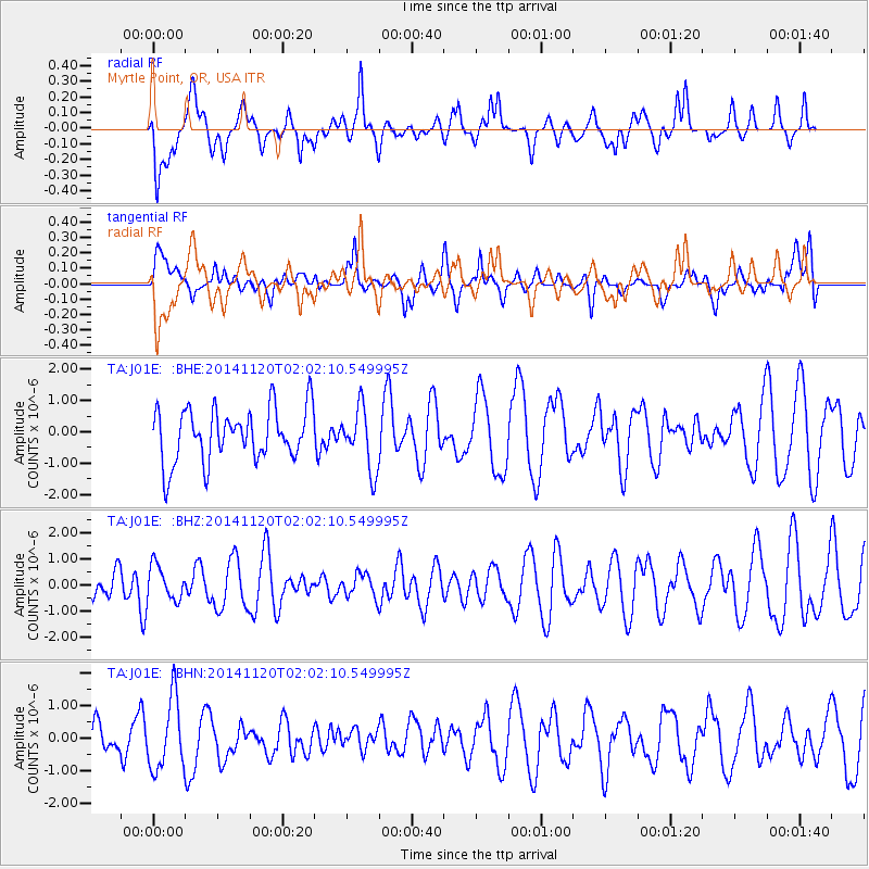
J01E Myrtle Point, OR, USA - Earthquake Result Viewer
*The percent match for this event was below the threshold and hence no stack was calculated.
| Earthquake location: |
Near East Coast Of Honshu, Japan |
| Earthquake latitude/longitude: |
37.3/141.6 |
| Earthquake time(UTC): |
2014/11/20 (324) 01:51:42 GMT |
| Earthquake Depth: |
32 km |
| Earthquake Magnitude: |
5.6 MWW, 5.5 MWB, 5.5 MWR, 5.6 MWC |
| Earthquake Catalog/Contributor: |
NEIC PDE/NEIC COMCAT |
|
| Network: |
TA USArray Transportable Network (new EarthScope stations) |
| Station: |
J01E Myrtle Point, OR, USA |
| Lat/Lon: |
43.16 N/123.93 W |
| Elevation: |
128 m |
|
| Distance: |
68.5 deg |
| Az: |
51.622 deg |
| Baz: |
301.341 deg |
| Ray Param: |
$rayparam |
*The percent match for this event was below the threshold and hence was not used in the summary stack. |
|
| Radial Match: |
47.881226 % |
| Radial Bump: |
400 |
| Transverse Match: |
47.681416 % |
| Transverse Bump: |
400 |
| SOD ConfigId: |
821188 |
| Insert Time: |
2014-12-15 05:38:20.718 +0000 |
| GWidth: |
2.5 |
| Max Bumps: |
400 |
| Tol: |
0.001 |
|
Signal To Noise
| Channel | StoN | STA | LTA |
| TA:J01E: :BHZ:20141120T02:02:10.549995Z | 1.2282932 | 6.560808E-7 | 5.341402E-7 |
| TA:J01E: :BHN:20141120T02:02:10.549995Z | 2.2093904 | 1.094439E-6 | 4.953579E-7 |
| TA:J01E: :BHE:20141120T02:02:10.549995Z | 1.1701344 | 9.835995E-7 | 8.405867E-7 |
| Arrivals |
| Ps | |
| PpPs | |
| PsPs/PpSs | |


