You are here: Home > Network List > TA - USArray Transportable Network (new EarthScope stations) Stations List
> Station J62A Henniker, NH, USA > Earthquake Result Viewer
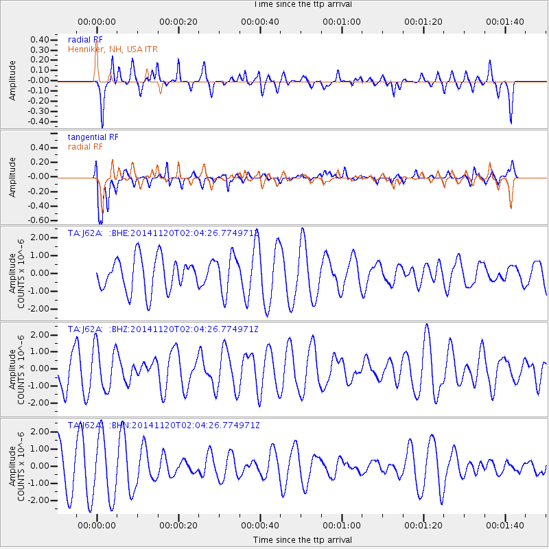
J62A Henniker, NH, USA - Earthquake Result Viewer
*The percent match for this event was below the threshold and hence no stack was calculated.
| Earthquake location: |
Near East Coast Of Honshu, Japan |
| Earthquake latitude/longitude: |
37.3/141.6 |
| Earthquake time(UTC): |
2014/11/20 (324) 01:51:42 GMT |
| Earthquake Depth: |
32 km |
| Earthquake Magnitude: |
5.6 MWW, 5.5 MWB, 5.5 MWR, 5.6 MWC |
| Earthquake Catalog/Contributor: |
NEIC PDE/NEIC COMCAT |
|
| Network: |
TA USArray Transportable Network (new EarthScope stations) |
| Station: |
J62A Henniker, NH, USA |
| Lat/Lon: |
43.23 N/71.81 W |
| Elevation: |
266 m |
|
| Distance: |
94.3 deg |
| Az: |
23.81 deg |
| Baz: |
333.878 deg |
| Ray Param: |
$rayparam |
*The percent match for this event was below the threshold and hence was not used in the summary stack. |
|
| Radial Match: |
67.054756 % |
| Radial Bump: |
394 |
| Transverse Match: |
65.21718 % |
| Transverse Bump: |
400 |
| SOD ConfigId: |
821188 |
| Insert Time: |
2014-12-15 05:38:32.357 +0000 |
| GWidth: |
2.5 |
| Max Bumps: |
400 |
| Tol: |
0.001 |
|
Signal To Noise
| Channel | StoN | STA | LTA |
| TA:J62A: :BHZ:20141120T02:04:26.774971Z | 1.2623204 | 1.3173473E-6 | 1.0435919E-6 |
| TA:J62A: :BHN:20141120T02:04:26.774971Z | 1.9493604 | 1.830902E-6 | 9.392322E-7 |
| TA:J62A: :BHE:20141120T02:04:26.774971Z | 1.158112 | 1.0698126E-6 | 9.237557E-7 |
| Arrivals |
| Ps | |
| PpPs | |
| PsPs/PpSs | |


