You are here: Home > Network List > TA - USArray Transportable Network (new EarthScope stations) Stations List
> Station SFIN Lafayette, IN, USA > Earthquake Result Viewer
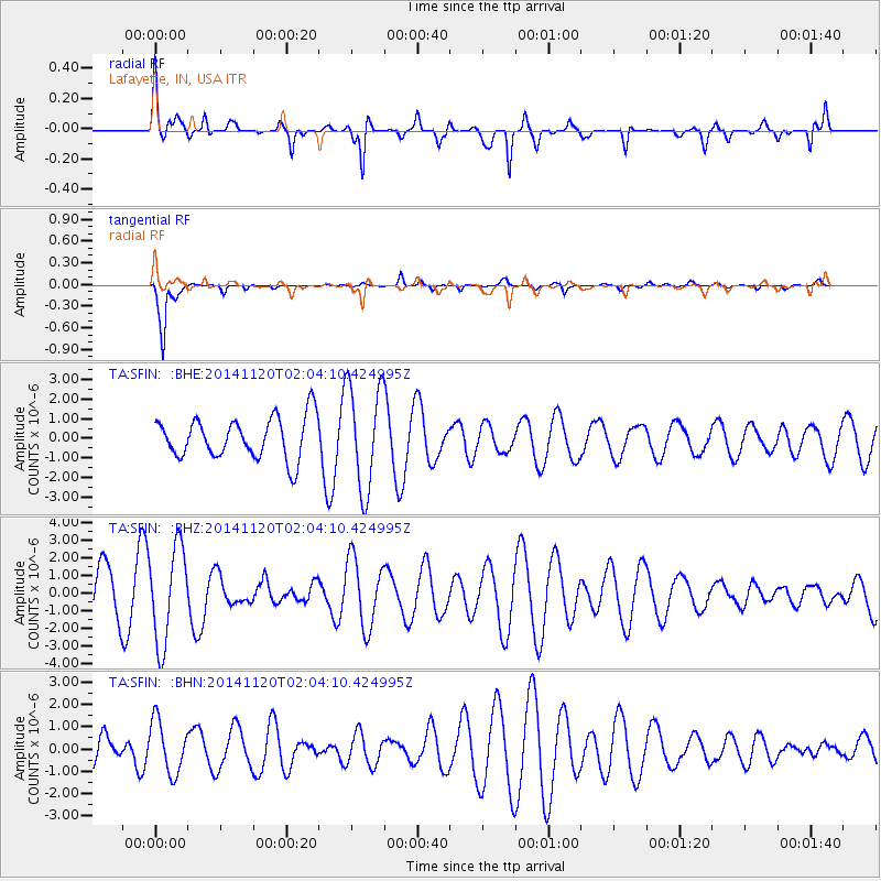
SFIN Lafayette, IN, USA - Earthquake Result Viewer
*The percent match for this event was below the threshold and hence no stack was calculated.
| Earthquake location: |
Near East Coast Of Honshu, Japan |
| Earthquake latitude/longitude: |
37.3/141.6 |
| Earthquake time(UTC): |
2014/11/20 (324) 01:51:42 GMT |
| Earthquake Depth: |
32 km |
| Earthquake Magnitude: |
5.6 MWW, 5.5 MWB, 5.5 MWR, 5.6 MWC |
| Earthquake Catalog/Contributor: |
NEIC PDE/NEIC COMCAT |
|
| Network: |
TA USArray Transportable Network (new EarthScope stations) |
| Station: |
SFIN Lafayette, IN, USA |
| Lat/Lon: |
40.38 N/87.10 W |
| Elevation: |
165 m |
|
| Distance: |
90.7 deg |
| Az: |
35.028 deg |
| Baz: |
323.203 deg |
| Ray Param: |
$rayparam |
*The percent match for this event was below the threshold and hence was not used in the summary stack. |
|
| Radial Match: |
56.080463 % |
| Radial Bump: |
400 |
| Transverse Match: |
94.887184 % |
| Transverse Bump: |
266 |
| SOD ConfigId: |
821188 |
| Insert Time: |
2014-12-15 05:40:30.046 +0000 |
| GWidth: |
2.5 |
| Max Bumps: |
400 |
| Tol: |
0.001 |
|
Signal To Noise
| Channel | StoN | STA | LTA |
| TA:SFIN: :BHZ:20141120T02:04:10.424995Z | 2.1596186 | 2.7161968E-6 | 1.2577207E-6 |
| TA:SFIN: :BHN:20141120T02:04:10.424995Z | 1.7820638 | 1.1758477E-6 | 6.5982357E-7 |
| TA:SFIN: :BHE:20141120T02:04:10.424995Z | 2.5532956 | 2.6809985E-6 | 1.0500149E-6 |
| Arrivals |
| Ps | |
| PpPs | |
| PsPs/PpSs | |


