You are here: Home > Network List > UW - Pacific Northwest Regional Seismic Network Stations List
> Station LCCR Mulino, OR, USA > Earthquake Result Viewer
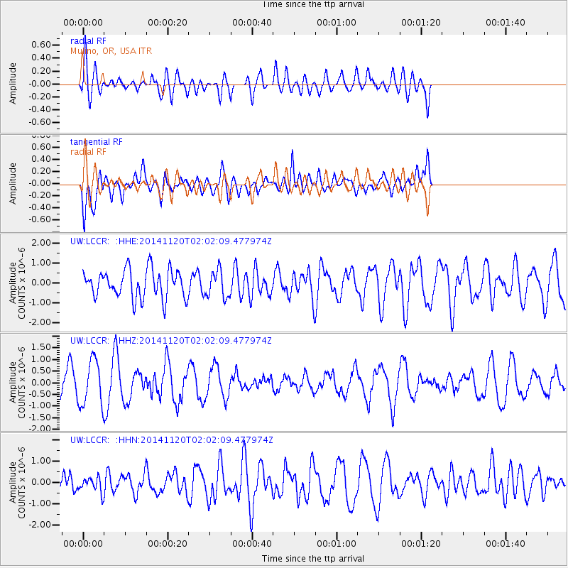
LCCR Mulino, OR, USA - Earthquake Result Viewer
*The percent match for this event was below the threshold and hence no stack was calculated.
| Earthquake location: |
Near East Coast Of Honshu, Japan |
| Earthquake latitude/longitude: |
37.3/141.6 |
| Earthquake time(UTC): |
2014/11/20 (324) 01:51:42 GMT |
| Earthquake Depth: |
32 km |
| Earthquake Magnitude: |
5.6 MWW, 5.5 MWB, 5.5 MWR, 5.6 MWC |
| Earthquake Catalog/Contributor: |
NEIC PDE/NEIC COMCAT |
|
| Network: |
UW Pacific Northwest Regional Seismic Network |
| Station: |
LCCR Mulino, OR, USA |
| Lat/Lon: |
45.21 N/122.48 W |
| Elevation: |
273 m |
|
| Distance: |
68.4 deg |
| Az: |
49.16 deg |
| Baz: |
301.446 deg |
| Ray Param: |
$rayparam |
*The percent match for this event was below the threshold and hence was not used in the summary stack. |
|
| Radial Match: |
51.14056 % |
| Radial Bump: |
400 |
| Transverse Match: |
63.313614 % |
| Transverse Bump: |
400 |
| SOD ConfigId: |
821188 |
| Insert Time: |
2014-12-15 05:43:52.211 +0000 |
| GWidth: |
2.5 |
| Max Bumps: |
400 |
| Tol: |
0.001 |
|
Signal To Noise
| Channel | StoN | STA | LTA |
| UW:LCCR: :HHZ:20141120T02:02:09.477974Z | 2.3062794 | 9.877963E-7 | 4.2830726E-7 |
| UW:LCCR: :HHN:20141120T02:02:09.477974Z | 0.47778416 | 3.5594033E-7 | 7.4498143E-7 |
| UW:LCCR: :HHE:20141120T02:02:09.477974Z | 0.9618814 | 6.9034854E-7 | 7.177065E-7 |
| Arrivals |
| Ps | |
| PpPs | |
| PsPs/PpSs | |


