You are here: Home > Network List > AU - Australian Seismological Centre Stations List
> Station LHI Lord Howe Island, Australia > Earthquake Result Viewer
LHI Lord Howe Island, Australia - Earthquake Result Viewer
| Earthquake location: |
Mindanao, Philippines |
| Earthquake latitude/longitude: |
6.1/123.1 |
| Earthquake time(UTC): |
2014/12/02 (336) 05:11:31 GMT |
| Earthquake Depth: |
614 km |
| Earthquake Magnitude: |
6.6 MWW, 6.6 MWC, 6.6 MWB |
| Earthquake Catalog/Contributor: |
NEIC PDE/NEIC COMCAT |
|
| Network: |
AU Australian Seismological Centre |
| Station: |
LHI Lord Howe Island, Australia |
| Lat/Lon: |
31.52 S/159.06 E |
| Elevation: |
74 m |
|
| Distance: |
50.7 deg |
| Az: |
139.665 deg |
| Baz: |
311.09 deg |
| Ray Param: |
0.06498517 |
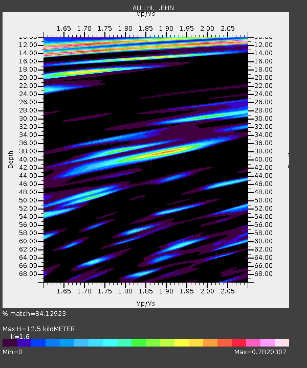
| Estimated Moho Depth: |
12.5 km |
| Estimated Crust Vp/Vs: |
1.60 |
| Assumed Crust Vp: |
4.157 km/s |
| Estimated Crust Vs: |
2.598 km/s |
| Estimated Crust Poisson's Ratio: |
0.18 |
|
| Radial Match: |
84.12923 % |
| Radial Bump: |
400 |
| Transverse Match: |
79.40401 % |
| Transverse Bump: |
400 |
| SOD ConfigId: |
821389 |
| Insert Time: |
2014-12-16 05:27:13.172 +0000 |
| GWidth: |
2.5 |
| Max Bumps: |
400 |
| Tol: |
0.001 |
|

Signal To Noise
| Channel | StoN | STA | LTA |
| AU:LHI: :BHZ:20141202T05:19:05.694004Z | 5.63315 | 3.0495312E-6 | 5.413545E-7 |
| AU:LHI: :BHN:20141202T05:19:05.694004Z | 1.8517284 | 1.0556743E-6 | 5.701021E-7 |
| AU:LHI: :BHE:20141202T05:19:05.694004Z | 3.7803664 | 1.490157E-6 | 3.9418325E-7 |
| Arrivals |
| Ps | 1.8 SECOND |
| PpPs | 7.6 SECOND |
| PsPs/PpSs | 9.5 SECOND |


