You are here: Home > Network List > AU - Australian Seismological Centre Stations List
> Station RABL Rabaul, Papau New Guinea > Earthquake Result Viewer
RABL Rabaul, Papau New Guinea - Earthquake Result Viewer
| Earthquake location: |
Mindanao, Philippines |
| Earthquake latitude/longitude: |
6.1/123.1 |
| Earthquake time(UTC): |
2014/12/02 (336) 05:11:31 GMT |
| Earthquake Depth: |
614 km |
| Earthquake Magnitude: |
6.6 MWW, 6.6 MWC, 6.6 MWB |
| Earthquake Catalog/Contributor: |
NEIC PDE/NEIC COMCAT |
|
| Network: |
AU Australian Seismological Centre |
| Station: |
RABL Rabaul, Papau New Guinea |
| Lat/Lon: |
4.19 S/152.16 E |
| Elevation: |
277 m |
|
| Distance: |
30.7 deg |
| Az: |
108.73 deg |
| Baz: |
289.221 deg |
| Ray Param: |
0.0764958 |
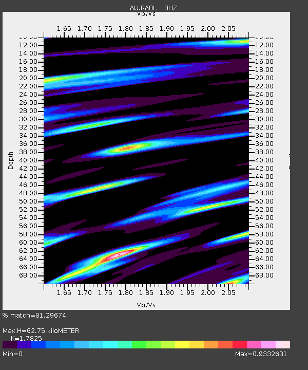
| Estimated Moho Depth: |
62.75 km |
| Estimated Crust Vp/Vs: |
1.78 |
| Assumed Crust Vp: |
6.183 km/s |
| Estimated Crust Vs: |
3.469 km/s |
| Estimated Crust Poisson's Ratio: |
0.27 |
|
| Radial Match: |
81.29674 % |
| Radial Bump: |
400 |
| Transverse Match: |
81.777626 % |
| Transverse Bump: |
400 |
| SOD ConfigId: |
821389 |
| Insert Time: |
2014-12-16 05:27:30.024 +0000 |
| GWidth: |
2.5 |
| Max Bumps: |
400 |
| Tol: |
0.001 |
|

Signal To Noise
| Channel | StoN | STA | LTA |
| AU:RABL: :BHZ:20141202T05:16:28.268986Z | 15.150695 | 1.1005282E-5 | 7.2638795E-7 |
| AU:RABL: :BHN:20141202T05:16:28.268986Z | 1.4923851 | 3.6579995E-6 | 2.4511096E-6 |
| AU:RABL: :BHE:20141202T05:16:28.268986Z | 2.852343 | 6.54766E-6 | 2.2955373E-6 |
| Arrivals |
| Ps | 8.5 SECOND |
| PpPs | 26 SECOND |
| PsPs/PpSs | 35 SECOND |


