You are here: Home > Network List > G - GEOSCOPE Stations List
> Station NOUC Port Laguerre, New Caledonia > Earthquake Result Viewer
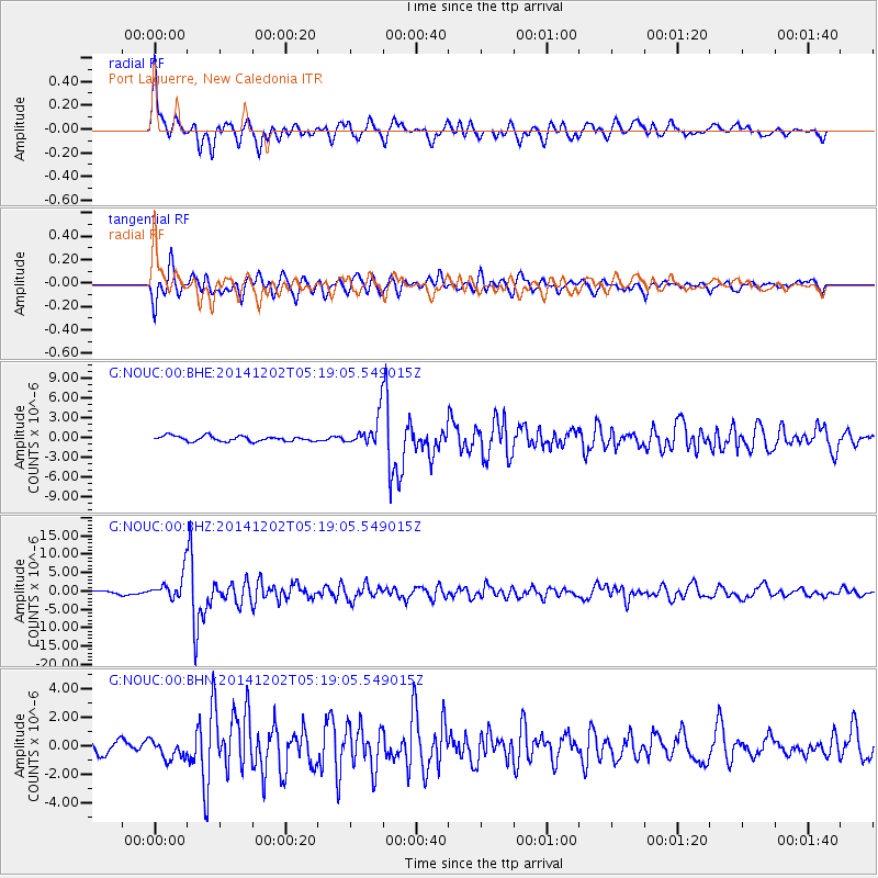
NOUC Port Laguerre, New Caledonia - Earthquake Result Viewer

| Earthquake location: |
Mindanao, Philippines |
| Earthquake latitude/longitude: |
6.1/123.1 |
| Earthquake time(UTC): |
2014/12/02 (336) 05:11:31 GMT |
| Earthquake Depth: |
614 km |
| Earthquake Magnitude: |
6.6 MWW, 6.6 MWC, 6.6 MWB |
| Earthquake Catalog/Contributor: |
NEIC PDE/NEIC COMCAT |
|
| Network: |
G GEOSCOPE |
| Station: |
NOUC Port Laguerre, New Caledonia |
| Lat/Lon: |
22.10 S/166.30 E |
| Elevation: |
112 m |
|
| Distance: |
50.7 deg |
| Az: |
124.937 deg |
| Baz: |
298.475 deg |
| Ray Param: |
0.06499969 |
| Estimated Moho Depth: |
18.5 km |
| Estimated Crust Vp/Vs: |
1.83 |
| Assumed Crust Vp: |
5.14 km/s |
| Estimated Crust Vs: |
2.816 km/s |
| Estimated Crust Poisson's Ratio: |
0.29 |
|
| Radial Match: |
80.66914 % |
| Radial Bump: |
400 |
| Transverse Match: |
80.4946 % |
| Transverse Bump: |
400 |
| SOD ConfigId: |
821389 |
| Insert Time: |
2014-12-16 05:29:13.413 +0000 |
| GWidth: |
2.5 |
| Max Bumps: |
400 |
| Tol: |
0.001 |
|
Signal To Noise
| Channel | StoN | STA | LTA |
| G:NOUC:00:BHZ:20141202T05:19:05.549015Z | 6.6642194 | 3.6187237E-6 | 5.430079E-7 |
| G:NOUC:00:BHN:20141202T05:19:05.549015Z | 1.4619584 | 6.619081E-7 | 4.5275436E-7 |
| G:NOUC:00:BHE:20141202T05:19:05.549015Z | 5.6381435 | 2.212647E-6 | 3.9244244E-7 |
| Arrivals |
| Ps | 3.1 SECOND |
| PpPs | 9.8 SECOND |
| PsPs/PpSs | 13 SECOND |


