You are here: Home > Network List > IU - Global Seismograph Network (GSN - IRIS/USGS) Stations List
> Station FURI Mt. Furi, Ethiopia > Earthquake Result Viewer
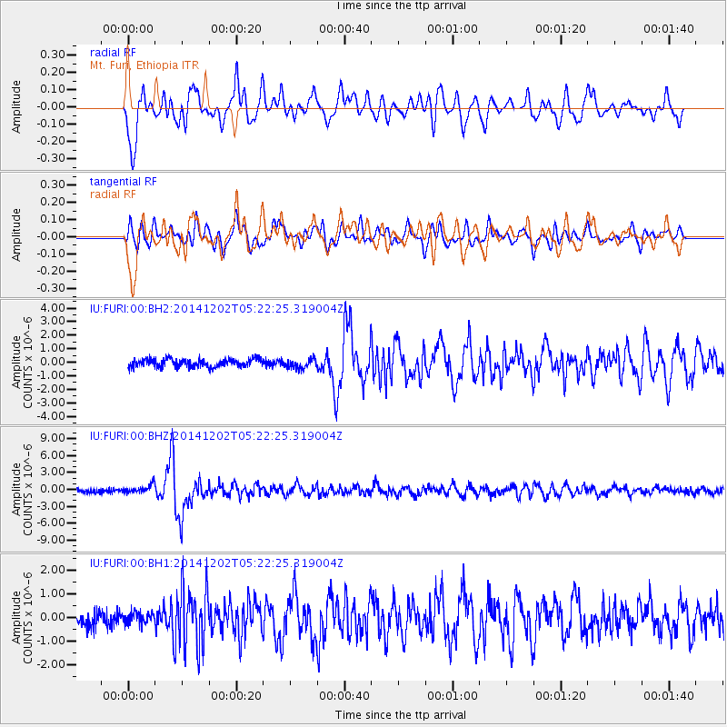
FURI Mt. Furi, Ethiopia - Earthquake Result Viewer
*The percent match for this event was below the threshold and hence no stack was calculated.
| Earthquake location: |
Mindanao, Philippines |
| Earthquake latitude/longitude: |
6.1/123.1 |
| Earthquake time(UTC): |
2014/12/02 (336) 05:11:31 GMT |
| Earthquake Depth: |
614 km |
| Earthquake Magnitude: |
6.6 MWW, 6.6 MWC, 6.6 MWB |
| Earthquake Catalog/Contributor: |
NEIC PDE/NEIC COMCAT |
|
| Network: |
IU Global Seismograph Network (GSN - IRIS/USGS) |
| Station: |
FURI Mt. Furi, Ethiopia |
| Lat/Lon: |
8.90 N/38.68 E |
| Elevation: |
2570 m |
|
| Distance: |
83.6 deg |
| Az: |
278.254 deg |
| Baz: |
84.838 deg |
| Ray Param: |
$rayparam |
*The percent match for this event was below the threshold and hence was not used in the summary stack. |
|
| Radial Match: |
83.09703 % |
| Radial Bump: |
400 |
| Transverse Match: |
76.52785 % |
| Transverse Bump: |
400 |
| SOD ConfigId: |
821389 |
| Insert Time: |
2014-12-16 05:31:49.109 +0000 |
| GWidth: |
2.5 |
| Max Bumps: |
400 |
| Tol: |
0.001 |
|
Signal To Noise
| Channel | StoN | STA | LTA |
| IU:FURI:00:BHZ:20141202T05:22:25.319004Z | 2.020466 | 7.606291E-7 | 3.764622E-7 |
| IU:FURI:00:BH1:20141202T05:22:25.319004Z | 0.8387834 | 2.4167434E-7 | 2.8812485E-7 |
| IU:FURI:00:BH2:20141202T05:22:25.319004Z | 1.2352414 | 3.7125903E-7 | 3.0055583E-7 |
| Arrivals |
| Ps | |
| PpPs | |
| PsPs/PpSs | |


