You are here: Home > Network List > KR - Kyrgyz Digital Network Stations List
> Station PRZ Karakol, Kyrgyzstan > Earthquake Result Viewer
PRZ Karakol, Kyrgyzstan - Earthquake Result Viewer
| Earthquake location: |
Mindanao, Philippines |
| Earthquake latitude/longitude: |
6.1/123.1 |
| Earthquake time(UTC): |
2014/12/02 (336) 05:11:31 GMT |
| Earthquake Depth: |
614 km |
| Earthquake Magnitude: |
6.6 MWW, 6.6 MWC, 6.6 MWB |
| Earthquake Catalog/Contributor: |
NEIC PDE/NEIC COMCAT |
|
| Network: |
KR Kyrgyz Digital Network |
| Station: |
PRZ Karakol, Kyrgyzstan |
| Lat/Lon: |
42.47 N/78.40 E |
| Elevation: |
1835 m |
|
| Distance: |
53.6 deg |
| Az: |
319.686 deg |
| Baz: |
119.587 deg |
| Ray Param: |
0.0632633 |
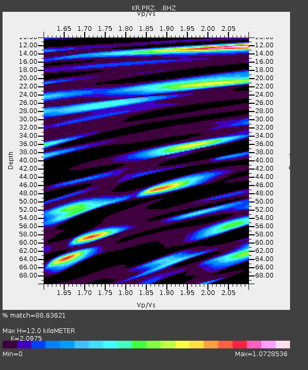
| Estimated Moho Depth: |
12.0 km |
| Estimated Crust Vp/Vs: |
2.10 |
| Assumed Crust Vp: |
6.306 km/s |
| Estimated Crust Vs: |
3.006 km/s |
| Estimated Crust Poisson's Ratio: |
0.35 |
|
| Radial Match: |
88.63621 % |
| Radial Bump: |
400 |
| Transverse Match: |
85.96819 % |
| Transverse Bump: |
400 |
| SOD ConfigId: |
821389 |
| Insert Time: |
2014-12-16 05:33:48.190 +0000 |
| GWidth: |
2.5 |
| Max Bumps: |
400 |
| Tol: |
0.001 |
|

Signal To Noise
| Channel | StoN | STA | LTA |
| KR:PRZ: :BHZ:20141202T05:19:25.85001Z | 4.6745625 | 1.4245234E-6 | 3.047394E-7 |
| KR:PRZ: :BHN:20141202T05:19:25.85001Z | 1.2447386 | 4.576416E-7 | 3.676608E-7 |
| KR:PRZ: :BHE:20141202T05:19:25.85001Z | 3.118358 | 5.702148E-7 | 1.8285739E-7 |
| Arrivals |
| Ps | 2.2 SECOND |
| PpPs | 5.7 SECOND |
| PsPs/PpSs | 7.8 SECOND |


