You are here: Home > Network List > 7A - Mid-Atlantic Geophysical Integrative Collaboration Stations List
> Station WLFT Gordonsville, Virginia USA > Earthquake Result Viewer
WLFT Gordonsville, Virginia USA - Earthquake Result Viewer
| Earthquake location: |
Near East Coast Of Honshu, Japan |
| Earthquake latitude/longitude: |
38.9/142.0 |
| Earthquake time(UTC): |
2015/05/12 (132) 21:12:58 GMT |
| Earthquake Depth: |
39 km |
| Earthquake Magnitude: |
6.8 MWP, 6.8 MI |
| Earthquake Catalog/Contributor: |
NEIC PDE/NEIC COMCAT |
|
| Network: |
7A Mid-Atlantic Geophysical Integrative Collaboration |
| Station: |
WLFT Gordonsville, Virginia USA |
| Lat/Lon: |
38.17 N/78.14 W |
| Elevation: |
110 m |
|
| Distance: |
94.9 deg |
| Az: |
30.689 deg |
| Baz: |
329.654 deg |
| Ray Param: |
0.04091155 |
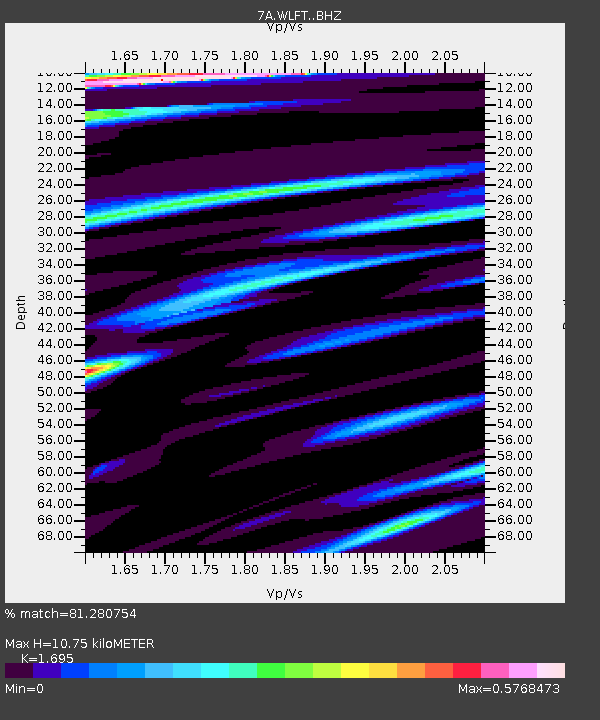
| Estimated Moho Depth: |
10.75 km |
| Estimated Crust Vp/Vs: |
1.70 |
| Assumed Crust Vp: |
6.159 km/s |
| Estimated Crust Vs: |
3.633 km/s |
| Estimated Crust Poisson's Ratio: |
0.23 |
|
| Radial Match: |
81.280754 % |
| Radial Bump: |
400 |
| Transverse Match: |
63.033287 % |
| Transverse Bump: |
400 |
| SOD ConfigId: |
7422571 |
| Insert Time: |
2019-04-18 20:40:12.081 +0000 |
| GWidth: |
2.5 |
| Max Bumps: |
400 |
| Tol: |
0.001 |
|

Signal To Noise
| Channel | StoN | STA | LTA |
| 7A:WLFT: :BHZ:20150512T21:25:45.18999Z | 6.088033 | 5.87914E-7 | 9.656878E-8 |
| 7A:WLFT: :BHN:20150512T21:25:45.18999Z | 2.996037 | 2.950309E-7 | 9.847372E-8 |
| 7A:WLFT: :BHE:20150512T21:25:45.18999Z | 0.7237475 | 8.364446E-8 | 1.15571325E-7 |
| Arrivals |
| Ps | 1.2 SECOND |
| PpPs | 4.6 SECOND |
| PsPs/PpSs | 5.9 SECOND |


