You are here: Home > Network List > AU - Australian Seismological Centre Stations List
> Station MTN Manton Dam, Northern Territory > Earthquake Result Viewer
MTN Manton Dam, Northern Territory - Earthquake Result Viewer
| Earthquake location: |
Near East Coast Of Honshu, Japan |
| Earthquake latitude/longitude: |
38.9/142.0 |
| Earthquake time(UTC): |
2015/05/12 (132) 21:12:58 GMT |
| Earthquake Depth: |
39 km |
| Earthquake Magnitude: |
6.8 MWP, 6.8 MI |
| Earthquake Catalog/Contributor: |
NEIC PDE/NEIC COMCAT |
|
| Network: |
AU Australian Seismological Centre |
| Station: |
MTN Manton Dam, Northern Territory |
| Lat/Lon: |
12.84 S/131.13 E |
| Elevation: |
137 m |
|
| Distance: |
52.5 deg |
| Az: |
193.447 deg |
| Baz: |
10.722 deg |
| Ray Param: |
0.06665645 |
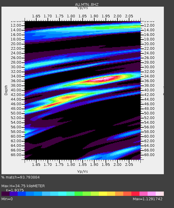
| Estimated Moho Depth: |
34.75 km |
| Estimated Crust Vp/Vs: |
1.94 |
| Assumed Crust Vp: |
6.61 km/s |
| Estimated Crust Vs: |
3.412 km/s |
| Estimated Crust Poisson's Ratio: |
0.32 |
|
| Radial Match: |
93.793884 % |
| Radial Bump: |
269 |
| Transverse Match: |
78.590004 % |
| Transverse Bump: |
400 |
| SOD ConfigId: |
7422571 |
| Insert Time: |
2019-04-18 20:41:33.542 +0000 |
| GWidth: |
2.5 |
| Max Bumps: |
400 |
| Tol: |
0.001 |
|

Signal To Noise
| Channel | StoN | STA | LTA |
| AU:MTN: :BHZ:20150512T21:21:36.918994Z | 7.4227223 | 2.4880999E-6 | 3.3520044E-7 |
| AU:MTN: :BHN:20150512T21:21:36.918994Z | 5.5655756 | 1.6475839E-6 | 2.9603117E-7 |
| AU:MTN: :BHE:20150512T21:21:36.918994Z | 1.9219016 | 3.13538E-7 | 1.6313948E-7 |
| Arrivals |
| Ps | 5.2 SECOND |
| PpPs | 15 SECOND |
| PsPs/PpSs | 20 SECOND |


