You are here: Home > Network List > CI - Caltech Regional Seismic Network Stations List
> Station SWS Sam W. Stewart, Westmorland, CA, USA > Earthquake Result Viewer
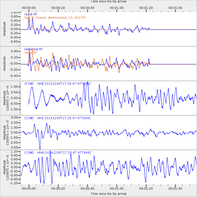
SWS Sam W. Stewart, Westmorland, CA, USA - Earthquake Result Viewer
*The percent match for this event was below the threshold and hence no stack was calculated.
| Earthquake location: |
South Of Panama |
| Earthquake latitude/longitude: |
8.0/-82.7 |
| Earthquake time(UTC): |
2014/12/06 (340) 17:21:48 GMT |
| Earthquake Depth: |
14 km |
| Earthquake Magnitude: |
6.0 MWW, 5.8 MWB, 6.0 MWC |
| Earthquake Catalog/Contributor: |
NEIC PDE/NEIC COMCAT |
|
| Network: |
CI Caltech Regional Seismic Network |
| Station: |
SWS Sam W. Stewart, Westmorland, CA, USA |
| Lat/Lon: |
32.94 N/115.80 W |
| Elevation: |
140 m |
|
| Distance: |
39.4 deg |
| Az: |
313.712 deg |
| Baz: |
121.639 deg |
| Ray Param: |
$rayparam |
*The percent match for this event was below the threshold and hence was not used in the summary stack. |
|
| Radial Match: |
80.2222 % |
| Radial Bump: |
339 |
| Transverse Match: |
65.53798 % |
| Transverse Bump: |
391 |
| SOD ConfigId: |
821842 |
| Insert Time: |
2014-12-20 17:35:00.995 +0000 |
| GWidth: |
2.5 |
| Max Bumps: |
400 |
| Tol: |
0.001 |
|
Signal To Noise
| Channel | StoN | STA | LTA |
| CI:SWS: :HHZ:20141206T17:28:47.477994Z | 3.7300084 | 6.481766E-7 | 1.737735E-7 |
| CI:SWS: :HHN:20141206T17:28:47.477994Z | 0.78856087 | 2.76229E-7 | 3.5029512E-7 |
| CI:SWS: :HHE:20141206T17:28:47.477994Z | 0.58468616 | 2.5095414E-7 | 4.2921172E-7 |
| Arrivals |
| Ps | |
| PpPs | |
| PsPs/PpSs | |


