You are here: Home > Network List > N4 - Central and EAstern US Network Stations List
> Station D32B Dogwood Acres, Gardner, ND, USA > Earthquake Result Viewer
D32B Dogwood Acres, Gardner, ND, USA - Earthquake Result Viewer
| Earthquake location: |
Near East Coast Of Honshu, Japan |
| Earthquake latitude/longitude: |
38.9/142.0 |
| Earthquake time(UTC): |
2015/05/12 (132) 21:12:58 GMT |
| Earthquake Depth: |
39 km |
| Earthquake Magnitude: |
6.8 MWP, 6.8 MI |
| Earthquake Catalog/Contributor: |
NEIC PDE/NEIC COMCAT |
|
| Network: |
N4 Central and EAstern US Network |
| Station: |
D32B Dogwood Acres, Gardner, ND, USA |
| Lat/Lon: |
47.14 N/97.02 W |
| Elevation: |
271 m |
|
| Distance: |
79.5 deg |
| Az: |
36.553 deg |
| Baz: |
317.104 deg |
| Ray Param: |
0.048889663 |
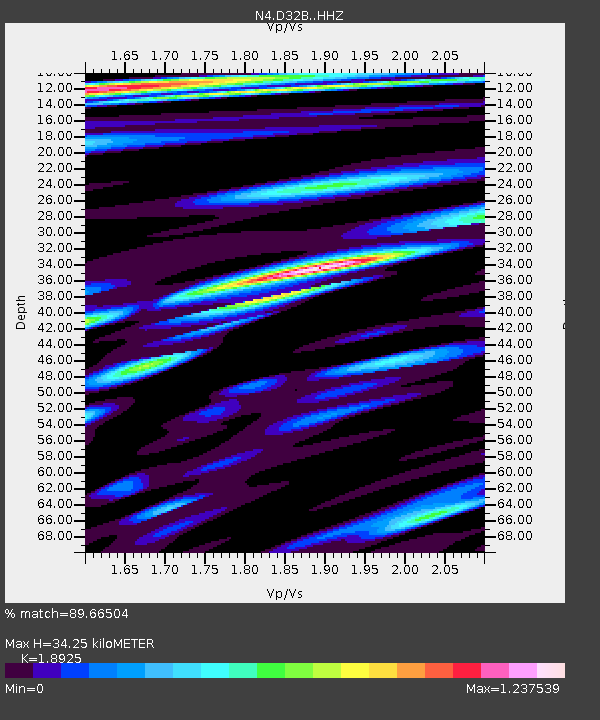
| Estimated Moho Depth: |
34.25 km |
| Estimated Crust Vp/Vs: |
1.89 |
| Assumed Crust Vp: |
6.498 km/s |
| Estimated Crust Vs: |
3.433 km/s |
| Estimated Crust Poisson's Ratio: |
0.31 |
|
| Radial Match: |
89.66504 % |
| Radial Bump: |
400 |
| Transverse Match: |
67.76601 % |
| Transverse Bump: |
400 |
| SOD ConfigId: |
7422571 |
| Insert Time: |
2019-04-18 20:46:11.316 +0000 |
| GWidth: |
2.5 |
| Max Bumps: |
400 |
| Tol: |
0.001 |
|

Signal To Noise
| Channel | StoN | STA | LTA |
| N4:D32B: :HHZ:20150512T21:24:29.879993Z | 15.311936 | 1.5271929E-6 | 9.973872E-8 |
| N4:D32B: :HHN:20150512T21:24:29.879993Z | 2.7373445 | 4.7317246E-7 | 1.7285822E-7 |
| N4:D32B: :HHE:20150512T21:24:29.879993Z | 3.1173742 | 4.4822625E-7 | 1.4378325E-7 |
| Arrivals |
| Ps | 4.8 SECOND |
| PpPs | 15 SECOND |
| PsPs/PpSs | 20 SECOND |


