You are here: Home > Network List > TA - USArray Transportable Network (new EarthScope stations) Stations List
> Station L44A Lake County Forest Preserve, Grayslake, IL, USA > Earthquake Result Viewer
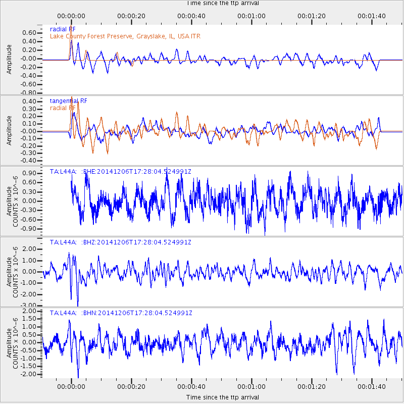
L44A Lake County Forest Preserve, Grayslake, IL, USA - Earthquake Result Viewer
*The percent match for this event was below the threshold and hence no stack was calculated.
| Earthquake location: |
South Of Panama |
| Earthquake latitude/longitude: |
8.0/-82.7 |
| Earthquake time(UTC): |
2014/12/06 (340) 17:21:48 GMT |
| Earthquake Depth: |
14 km |
| Earthquake Magnitude: |
6.0 MWW, 5.8 MWB, 6.0 MWC |
| Earthquake Catalog/Contributor: |
NEIC PDE/NEIC COMCAT |
|
| Network: |
TA USArray Transportable Network (new EarthScope stations) |
| Station: |
L44A Lake County Forest Preserve, Grayslake, IL, USA |
| Lat/Lon: |
42.18 N/87.91 W |
| Elevation: |
202 m |
|
| Distance: |
34.4 deg |
| Az: |
353.15 deg |
| Baz: |
170.856 deg |
| Ray Param: |
$rayparam |
*The percent match for this event was below the threshold and hence was not used in the summary stack. |
|
| Radial Match: |
68.52101 % |
| Radial Bump: |
400 |
| Transverse Match: |
62.307213 % |
| Transverse Bump: |
400 |
| SOD ConfigId: |
821842 |
| Insert Time: |
2014-12-20 17:56:01.873 +0000 |
| GWidth: |
2.5 |
| Max Bumps: |
400 |
| Tol: |
0.001 |
|
Signal To Noise
| Channel | StoN | STA | LTA |
| TA:L44A: :BHZ:20141206T17:28:04.524991Z | 3.7815232 | 1.2534132E-6 | 3.3145724E-7 |
| TA:L44A: :BHN:20141206T17:28:04.524991Z | 2.4746754 | 8.407669E-7 | 3.3974837E-7 |
| TA:L44A: :BHE:20141206T17:28:04.524991Z | 1.3963033 | 4.7008132E-7 | 3.3666132E-7 |
| Arrivals |
| Ps | |
| PpPs | |
| PsPs/PpSs | |


