You are here: Home > Network List > TA - USArray Transportable Network (new EarthScope stations) Stations List
> Station Q56A Snyder Ridge, Maysville, WV, USA > Earthquake Result Viewer
Q56A Snyder Ridge, Maysville, WV, USA - Earthquake Result Viewer

| Earthquake location: |
South Of Panama |
| Earthquake latitude/longitude: |
8.0/-82.7 |
| Earthquake time(UTC): |
2014/12/06 (340) 17:21:48 GMT |
| Earthquake Depth: |
14 km |
| Earthquake Magnitude: |
6.0 MWW, 5.8 MWB, 6.0 MWC |
| Earthquake Catalog/Contributor: |
NEIC PDE/NEIC COMCAT |
|
| Network: |
TA USArray Transportable Network (new EarthScope stations) |
| Station: |
Q56A Snyder Ridge, Maysville, WV, USA |
| Lat/Lon: |
39.04 N/79.19 W |
| Elevation: |
430 m |
|
| Distance: |
31.1 deg |
| Az: |
5.327 deg |
| Baz: |
186.781 deg |
| Ray Param: |
0.079157814 |
| Estimated Moho Depth: |
54.25 km |
| Estimated Crust Vp/Vs: |
1.75 |
| Assumed Crust Vp: |
6.159 km/s |
| Estimated Crust Vs: |
3.524 km/s |
| Estimated Crust Poisson's Ratio: |
0.26 |
|
| Radial Match: |
83.222984 % |
| Radial Bump: |
400 |
| Transverse Match: |
50.541153 % |
| Transverse Bump: |
400 |
| SOD ConfigId: |
821842 |
| Insert Time: |
2014-12-20 17:58:04.541 +0000 |
| GWidth: |
2.5 |
| Max Bumps: |
400 |
| Tol: |
0.001 |
|
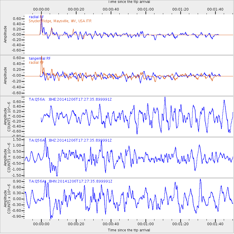
Signal To Noise
| Channel | StoN | STA | LTA |
| TA:Q56A: :BHZ:20141206T17:27:35.899991Z | 2.9773214 | 6.392768E-7 | 2.147154E-7 |
| TA:Q56A: :BHN:20141206T17:27:35.899991Z | 1.5214671 | 4.282415E-7 | 2.8146616E-7 |
| TA:Q56A: :BHE:20141206T17:27:35.899991Z | 1.1870478 | 1.8785224E-7 | 1.5825162E-7 |
| Arrivals |
| Ps | 7.1 SECOND |
| PpPs | 22 SECOND |
| PsPs/PpSs | 30 SECOND |


