You are here: Home > Network List > N4 - Central and EAstern US Network Stations List
> Station M50A Fremont, OH, USA > Earthquake Result Viewer
M50A Fremont, OH, USA - Earthquake Result Viewer
| Earthquake location: |
Near East Coast Of Honshu, Japan |
| Earthquake latitude/longitude: |
38.9/142.0 |
| Earthquake time(UTC): |
2015/05/12 (132) 21:12:58 GMT |
| Earthquake Depth: |
39 km |
| Earthquake Magnitude: |
6.8 MWP, 6.8 MI |
| Earthquake Catalog/Contributor: |
NEIC PDE/NEIC COMCAT |
|
| Network: |
N4 Central and EAstern US Network |
| Station: |
M50A Fremont, OH, USA |
| Lat/Lon: |
41.40 N/83.04 W |
| Elevation: |
176 m |
|
| Distance: |
90.1 deg |
| Az: |
32.184 deg |
| Baz: |
326.464 deg |
| Ray Param: |
0.0416894 |
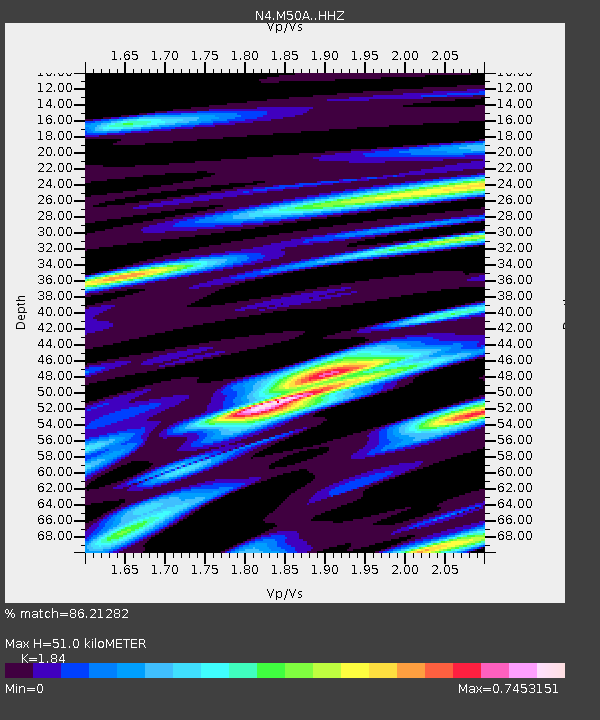
| Estimated Moho Depth: |
51.0 km |
| Estimated Crust Vp/Vs: |
1.84 |
| Assumed Crust Vp: |
6.498 km/s |
| Estimated Crust Vs: |
3.531 km/s |
| Estimated Crust Poisson's Ratio: |
0.29 |
|
| Radial Match: |
86.21282 % |
| Radial Bump: |
400 |
| Transverse Match: |
74.48171 % |
| Transverse Bump: |
400 |
| SOD ConfigId: |
7422571 |
| Insert Time: |
2019-04-18 20:46:36.392 +0000 |
| GWidth: |
2.5 |
| Max Bumps: |
400 |
| Tol: |
0.001 |
|

Signal To Noise
| Channel | StoN | STA | LTA |
| N4:M50A: :HHZ:20150512T21:25:23.400012Z | 6.3209867 | 1.0503157E-6 | 1.6616326E-7 |
| N4:M50A: :HHN:20150512T21:25:23.400012Z | 1.4394479 | 5.046374E-7 | 3.5057707E-7 |
| N4:M50A: :HHE:20150512T21:25:23.400012Z | 0.9068665 | 2.836506E-7 | 3.1278097E-7 |
| Arrivals |
| Ps | 6.7 SECOND |
| PpPs | 22 SECOND |
| PsPs/PpSs | 29 SECOND |


