You are here: Home > Network List > TA - USArray Transportable Network (new EarthScope stations) Stations List
> Station R56A Bull Pasture Mountain, McDowell, VA, USA > Earthquake Result Viewer
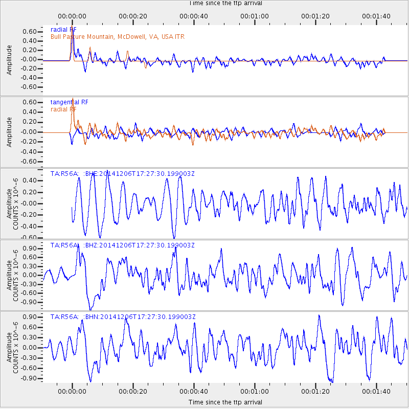
R56A Bull Pasture Mountain, McDowell, VA, USA - Earthquake Result Viewer
*The percent match for this event was below the threshold and hence no stack was calculated.
| Earthquake location: |
South Of Panama |
| Earthquake latitude/longitude: |
8.0/-82.7 |
| Earthquake time(UTC): |
2014/12/06 (340) 17:21:48 GMT |
| Earthquake Depth: |
14 km |
| Earthquake Magnitude: |
6.0 MWW, 5.8 MWB, 6.0 MWC |
| Earthquake Catalog/Contributor: |
NEIC PDE/NEIC COMCAT |
|
| Network: |
TA USArray Transportable Network (new EarthScope stations) |
| Station: |
R56A Bull Pasture Mountain, McDowell, VA, USA |
| Lat/Lon: |
38.41 N/79.40 W |
| Elevation: |
902 m |
|
| Distance: |
30.4 deg |
| Az: |
5.142 deg |
| Baz: |
186.487 deg |
| Ray Param: |
$rayparam |
*The percent match for this event was below the threshold and hence was not used in the summary stack. |
|
| Radial Match: |
73.52683 % |
| Radial Bump: |
400 |
| Transverse Match: |
63.60494 % |
| Transverse Bump: |
400 |
| SOD ConfigId: |
821842 |
| Insert Time: |
2014-12-20 17:58:24.445 +0000 |
| GWidth: |
2.5 |
| Max Bumps: |
400 |
| Tol: |
0.001 |
|
Signal To Noise
| Channel | StoN | STA | LTA |
| TA:R56A: :BHZ:20141206T17:27:30.199003Z | 2.6348388 | 5.144111E-7 | 1.9523439E-7 |
| TA:R56A: :BHN:20141206T17:27:30.199003Z | 1.6356019 | 4.0832867E-7 | 2.4965038E-7 |
| TA:R56A: :BHE:20141206T17:27:30.199003Z | 1.1080439 | 3.314669E-7 | 2.9914602E-7 |
| Arrivals |
| Ps | |
| PpPs | |
| PsPs/PpSs | |


