You are here: Home > Network List > NI - North-East Italy Broadband Network Stations List
> Station ACOM Acomizza > Earthquake Result Viewer
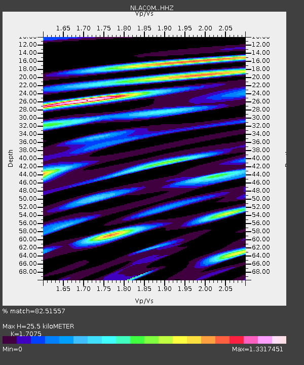
ACOM Acomizza - Earthquake Result Viewer
| Earthquake location: |
Near East Coast Of Honshu, Japan |
| Earthquake latitude/longitude: |
38.9/142.0 |
| Earthquake time(UTC): |
2015/05/12 (132) 21:12:58 GMT |
| Earthquake Depth: |
39 km |
| Earthquake Magnitude: |
6.8 MWP, 6.8 MI |
| Earthquake Catalog/Contributor: |
NEIC PDE/NEIC COMCAT |
|
| Network: |
NI North-East Italy Broadband Network |
| Station: |
ACOM Acomizza |
| Lat/Lon: |
46.55 N/13.51 E |
| Elevation: |
1715 m |
|
| Distance: |
83.3 deg |
| Az: |
327.06 deg |
| Baz: |
37.933 deg |
| Ray Param: |
0.04625054 |
| Estimated Moho Depth: |
25.5 km |
| Estimated Crust Vp/Vs: |
1.71 |
| Assumed Crust Vp: |
6.35 km/s |
| Estimated Crust Vs: |
3.719 km/s |
| Estimated Crust Poisson's Ratio: |
0.24 |
|
| Radial Match: |
82.51557 % |
| Radial Bump: |
400 |
| Transverse Match: |
79.69591 % |
| Transverse Bump: |
400 |
| SOD ConfigId: |
7422571 |
| Insert Time: |
2019-04-18 20:47:36.076 +0000 |
| GWidth: |
2.5 |
| Max Bumps: |
400 |
| Tol: |
0.001 |
|

Signal To Noise
| Channel | StoN | STA | LTA |
| NI:ACOM: :HHZ:20150512T21:24:49.947986Z | 35.922672 | 3.965104E-6 | 1.1037888E-7 |
| NI:ACOM: :HHN:20150512T21:24:49.947986Z | 12.299741 | 1.8296957E-6 | 1.4875889E-7 |
| NI:ACOM: :HHE:20150512T21:24:49.947986Z | 15.887473 | 1.6101726E-6 | 1.0134856E-7 |
| Arrivals |
| Ps | 2.9 SECOND |
| PpPs | 11 SECOND |
| PsPs/PpSs | 14 SECOND |


