You are here: Home > Network List > IU - Global Seismograph Network (GSN - IRIS/USGS) Stations List
> Station RAIO Rainier, Oregon, USA > Earthquake Result Viewer
RAIO Rainier, Oregon, USA - Earthquake Result Viewer
| Earthquake location: |
Southeast Of Loyalty Islands |
| Earthquake latitude/longitude: |
-22.3/170.9 |
| Earthquake time(UTC): |
1998/01/04 (004) 06:11:58 GMT |
| Earthquake Depth: |
101 km |
| Earthquake Magnitude: |
6.4 MB, 7.4 UNKNOWN, 7.3 ME |
| Earthquake Catalog/Contributor: |
WHDF/NEIC |
|
| Network: |
IU Global Seismograph Network (GSN - IRIS/USGS) |
| Station: |
RAIO Rainier, Oregon, USA |
| Lat/Lon: |
46.04 N/122.89 W |
| Elevation: |
11 m |
|
| Distance: |
90.6 deg |
| Az: |
39.597 deg |
| Baz: |
237.931 deg |
| Ray Param: |
0.04164227 |
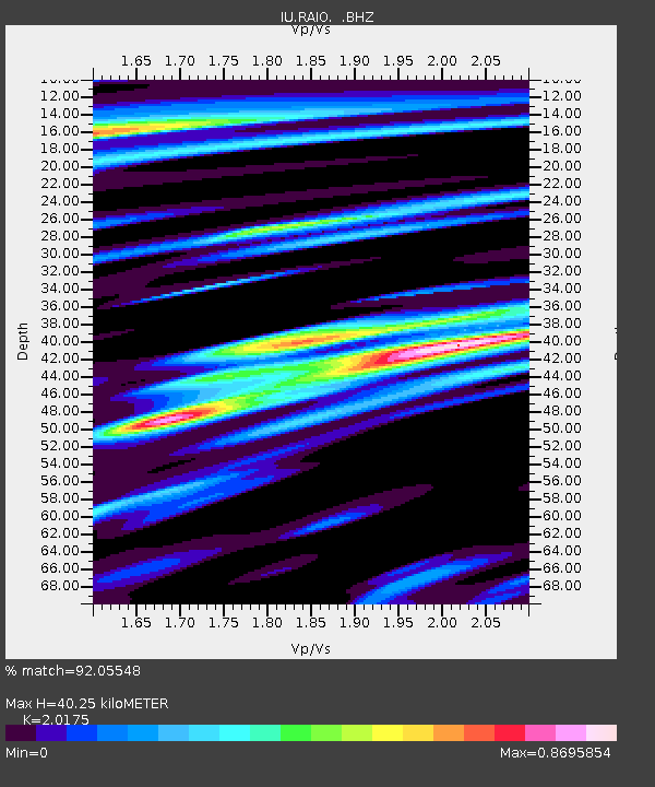
| Estimated Moho Depth: |
40.25 km |
| Estimated Crust Vp/Vs: |
2.02 |
| Assumed Crust Vp: |
6.566 km/s |
| Estimated Crust Vs: |
3.255 km/s |
| Estimated Crust Poisson's Ratio: |
0.34 |
|
| Radial Match: |
92.05548 % |
| Radial Bump: |
400 |
| Transverse Match: |
82.65193 % |
| Transverse Bump: |
400 |
| SOD ConfigId: |
4480 |
| Insert Time: |
2010-03-02 14:36:48.059 +0000 |
| GWidth: |
2.5 |
| Max Bumps: |
400 |
| Tol: |
0.001 |
|

Signal To Noise
| Channel | StoN | STA | LTA |
| IU:RAIO: :BHZ:19980104T06:24:18.621008Z | 1.9246469 | 8.8087035E-7 | 4.5767894E-7 |
| IU:RAIO: :BHN:19980104T06:24:18.621008Z | 1.4827846 | 6.9760296E-7 | 4.7046817E-7 |
| IU:RAIO: :BHE:19980104T06:24:18.621008Z | 0.65890026 | 4.0798304E-7 | 6.1918786E-7 |
| Arrivals |
| Ps | 6.4 SECOND |
| PpPs | 18 SECOND |
| PsPs/PpSs | 25 SECOND |


