You are here: Home > Network List > IU - Global Seismograph Network (GSN - IRIS/USGS) Stations List
> Station RAIO Rainier, Oregon, USA > Earthquake Result Viewer
RAIO Rainier, Oregon, USA - Earthquake Result Viewer
| Earthquake location: |
Guatemala |
| Earthquake latitude/longitude: |
14.4/-91.5 |
| Earthquake time(UTC): |
1998/01/10 (010) 08:20:05 GMT |
| Earthquake Depth: |
33 km |
| Earthquake Magnitude: |
6.1 MB, 6.2 MS, 6.6 UNKNOWN, 6.6 ME |
| Earthquake Catalog/Contributor: |
WHDF/NEIC |
|
| Network: |
IU Global Seismograph Network (GSN - IRIS/USGS) |
| Station: |
RAIO Rainier, Oregon, USA |
| Lat/Lon: |
46.04 N/122.89 W |
| Elevation: |
11 m |
|
| Distance: |
41.1 deg |
| Az: |
326.508 deg |
| Baz: |
129.851 deg |
| Ray Param: |
0.07391174 |
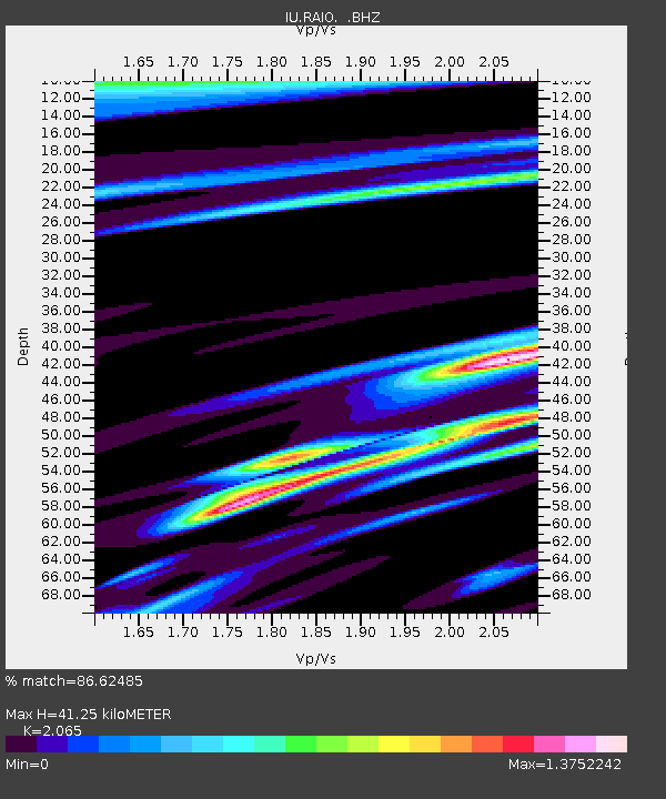
| Estimated Moho Depth: |
41.25 km |
| Estimated Crust Vp/Vs: |
2.07 |
| Assumed Crust Vp: |
6.566 km/s |
| Estimated Crust Vs: |
3.18 km/s |
| Estimated Crust Poisson's Ratio: |
0.35 |
|
| Radial Match: |
86.62485 % |
| Radial Bump: |
400 |
| Transverse Match: |
71.431526 % |
| Transverse Bump: |
400 |
| SOD ConfigId: |
4480 |
| Insert Time: |
2010-03-02 14:36:50.752 +0000 |
| GWidth: |
2.5 |
| Max Bumps: |
400 |
| Tol: |
0.001 |
|

Signal To Noise
| Channel | StoN | STA | LTA |
| IU:RAIO: :BHZ:19980110T08:27:16.245013Z | 26.38688 | 8.709201E-6 | 3.30058E-7 |
| IU:RAIO: :BHN:19980110T08:27:16.245013Z | 4.8678684 | 1.7659461E-6 | 3.6277606E-7 |
| IU:RAIO: :BHE:19980110T08:27:16.245013Z | 4.6956525 | 2.0876753E-6 | 4.445975E-7 |
| Arrivals |
| Ps | 7.1 SECOND |
| PpPs | 18 SECOND |
| PsPs/PpSs | 25 SECOND |


