You are here: Home > Network List > NX - Nanometrics Research Network Stations List
> Station STN16 Seismic station 16 > Earthquake Result Viewer
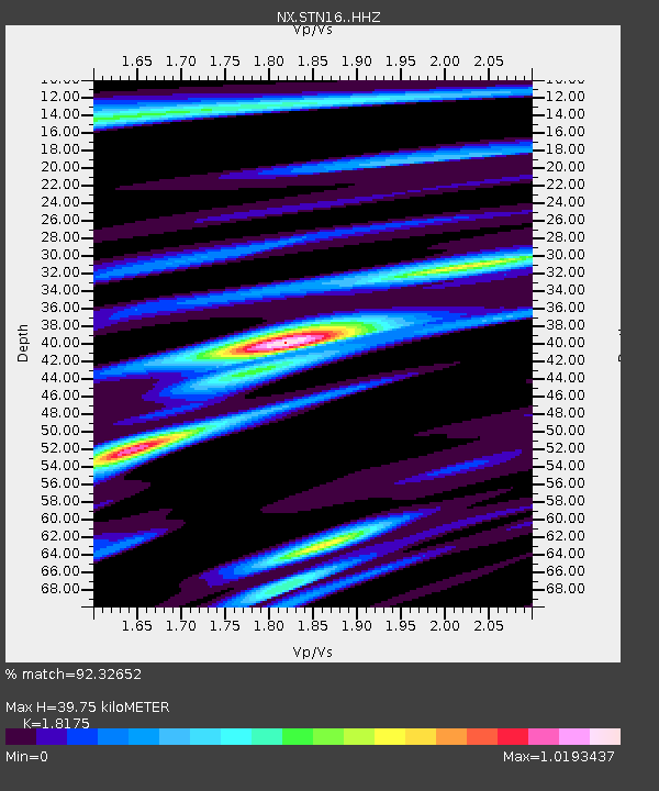
STN16 Seismic station 16 - Earthquake Result Viewer
| Earthquake location: |
Near East Coast Of Honshu, Japan |
| Earthquake latitude/longitude: |
38.9/142.0 |
| Earthquake time(UTC): |
2015/05/12 (132) 21:12:58 GMT |
| Earthquake Depth: |
39 km |
| Earthquake Magnitude: |
6.8 MWP, 6.8 MI |
| Earthquake Catalog/Contributor: |
NEIC PDE/NEIC COMCAT |
|
| Network: |
NX Nanometrics Research Network |
| Station: |
STN16 Seismic station 16 |
| Lat/Lon: |
36.35 N/97.13 W |
| Elevation: |
294 m |
|
| Distance: |
87.4 deg |
| Az: |
43.94 deg |
| Baz: |
317.882 deg |
| Ray Param: |
0.043329686 |
| Estimated Moho Depth: |
39.75 km |
| Estimated Crust Vp/Vs: |
1.82 |
| Assumed Crust Vp: |
6.483 km/s |
| Estimated Crust Vs: |
3.567 km/s |
| Estimated Crust Poisson's Ratio: |
0.28 |
|
| Radial Match: |
92.32652 % |
| Radial Bump: |
359 |
| Transverse Match: |
78.43701 % |
| Transverse Bump: |
400 |
| SOD ConfigId: |
7422571 |
| Insert Time: |
2019-04-18 20:48:18.579 +0000 |
| GWidth: |
2.5 |
| Max Bumps: |
400 |
| Tol: |
0.001 |
|

Signal To Noise
| Channel | StoN | STA | LTA |
| NX:STN16: :HHZ:20150512T21:25:10.309985Z | 18.52725 | 1.0122995E-6 | 5.4638413E-8 |
| NX:STN16: :HH1:20150512T21:25:10.309985Z | 3.0559092 | 3.65674E-7 | 1.1966128E-7 |
| NX:STN16: :HH2:20150512T21:25:10.309985Z | 2.3977535 | 2.3939893E-7 | 9.984301E-8 |
| Arrivals |
| Ps | 5.1 SECOND |
| PpPs | 17 SECOND |
| PsPs/PpSs | 22 SECOND |


