You are here: Home > Network List > G - GEOSCOPE Stations List
> Station NOUC Port Laguerre, New Caledonia > Earthquake Result Viewer
NOUC Port Laguerre, New Caledonia - Earthquake Result Viewer
| Earthquake location: |
Banda Sea |
| Earthquake latitude/longitude: |
-6.1/130.5 |
| Earthquake time(UTC): |
2014/12/06 (340) 22:05:10 GMT |
| Earthquake Depth: |
117 km |
| Earthquake Magnitude: |
6.0 MB |
| Earthquake Catalog/Contributor: |
NEIC PDE/NEIC COMCAT |
|
| Network: |
G GEOSCOPE |
| Station: |
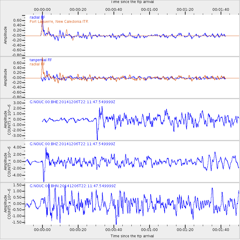
NOUC Port Laguerre, New Caledonia |
| Lat/Lon: |
22.10 S/166.30 E |
| Elevation: |
112 m |
|
| Distance: |
38.1 deg |
| Az: |
118.305 deg |
| Baz: |
289.262 deg |
| Ray Param: |
0.07537285 |
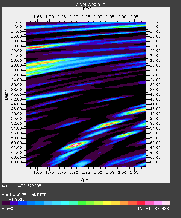
| Estimated Moho Depth: |
60.75 km |
| Estimated Crust Vp/Vs: |
1.80 |
| Assumed Crust Vp: |
5.14 km/s |
| Estimated Crust Vs: |
2.852 km/s |
| Estimated Crust Poisson's Ratio: |
0.28 |
|
| Radial Match: |
83.642395 % |
| Radial Bump: |
400 |
| Transverse Match: |
62.240665 % |
| Transverse Bump: |
400 |
| SOD ConfigId: |
822622 |
| Insert Time: |
2014-12-20 22:23:55.564 +0000 |
| GWidth: |
2.5 |
| Max Bumps: |
400 |
| Tol: |
0.001 |
|
Signal To Noise
| Channel | StoN | STA | LTA |
| G:NOUC:00:BHZ:20141206T22:11:47.549999Z | 7.136307 | 2.2687102E-6 | 3.1791095E-7 |
| G:NOUC:00:BHN:20141206T22:11:47.549999Z | 3.6643481 | 6.409674E-7 | 1.7491989E-7 |
| G:NOUC:00:BHE:20141206T22:11:47.549999Z | 7.03859 | 1.4672808E-6 | 2.0846232E-7 |
| Arrivals |
| Ps | 9.9 SECOND |
| PpPs | 32 SECOND |
| PsPs/PpSs | 42 SECOND |


