You are here: Home > Network List > NX - Nanometrics Research Network Stations List
> Station STN31 Seismic station 26 > Earthquake Result Viewer
STN31 Seismic station 26 - Earthquake Result Viewer
| Earthquake location: |
Near East Coast Of Honshu, Japan |
| Earthquake latitude/longitude: |
38.9/142.0 |
| Earthquake time(UTC): |
2015/05/12 (132) 21:12:58 GMT |
| Earthquake Depth: |
39 km |
| Earthquake Magnitude: |
6.8 MWP, 6.8 MI |
| Earthquake Catalog/Contributor: |
NEIC PDE/NEIC COMCAT |
|
| Network: |
NX Nanometrics Research Network |
| Station: |
STN31 Seismic station 26 |
| Lat/Lon: |
35.76 N/97.44 W |
| Elevation: |
329 m |
|
| Distance: |
87.6 deg |
| Az: |
44.526 deg |
| Baz: |
317.723 deg |
| Ray Param: |
0.04313805 |
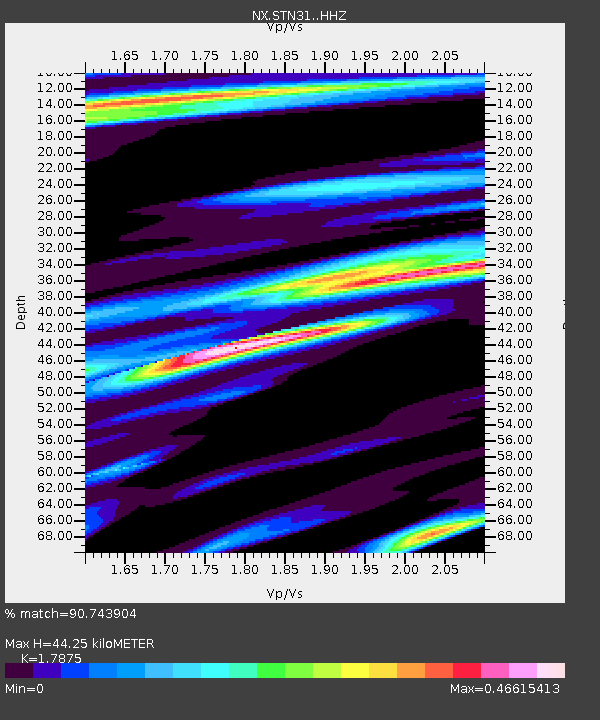
| Estimated Moho Depth: |
44.25 km |
| Estimated Crust Vp/Vs: |
1.79 |
| Assumed Crust Vp: |
6.426 km/s |
| Estimated Crust Vs: |
3.595 km/s |
| Estimated Crust Poisson's Ratio: |
0.27 |
|
| Radial Match: |
90.743904 % |
| Radial Bump: |
353 |
| Transverse Match: |
81.1571 % |
| Transverse Bump: |
400 |
| SOD ConfigId: |
7422571 |
| Insert Time: |
2019-04-18 20:48:25.035 +0000 |
| GWidth: |
2.5 |
| Max Bumps: |
400 |
| Tol: |
0.001 |
|

Signal To Noise
| Channel | StoN | STA | LTA |
| NX:STN31: :HHZ:20150512T21:25:11.580005Z | 6.617767 | 1.131237E-6 | 1.7093939E-7 |
| NX:STN31: :HH1:20150512T21:25:11.580005Z | 0.92965823 | 1.8168197E-7 | 1.9542878E-7 |
| NX:STN31: :HH2:20150512T21:25:11.580005Z | 1.0865686 | 2.3130242E-7 | 2.1287421E-7 |
| Arrivals |
| Ps | 5.5 SECOND |
| PpPs | 19 SECOND |
| PsPs/PpSs | 24 SECOND |


