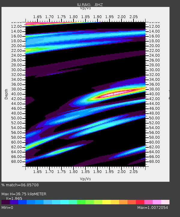
RAIO Rainier, Oregon, USA - Earthquake Result Viewer

Earthquake location: Andreanof Islands, Aleutian Is.
Earthquake latitude/longitude: 51.3/-179.3
Earthquake time(UTC): 1997/06/17 (168) 21:03:40 GMT
Earthquake Depth: 33 km
Earthquake Magnitude: 6.4 MB, 6.3 MS, 6.4 UNKNOWN, 6.6 ML
Earthquake Catalog/Contributor: WHDF/NEIC
Network: IU Global Seismograph Network (GSN - IRIS/USGS)
Station: RAIO Rainier, Oregon, USA
Lat/Lon: 46.04 N/122.89 W
Elevation: 11 m
Distance: 36.8 deg
Az: 75.501 deg
Baz: 299.345 deg
Ray Param: 0.07640007
Estimated Moho Depth: 39.75 km
Estimated Crust Vp/Vs: 1.97
Assumed Crust Vp: 6.566 km/s
Estimated Crust Vs: 3.342 km/s
Estimated Crust Poisson's Ratio: 0.33
Radial Match: 86.85708 %
Radial Bump: 400
Transverse Match: 76.44397 %
Transverse Bump: 400
SOD ConfigId: 4480
Insert Time: 2010-03-02 14:37:07.720 +0000
GWidth: 2.5
Max Bumps: 400
Tol: 0.001

Signal To Noise

ChannelStoNSTALTA
IU:RAIO: :BHZ:19970617T21:10:14.844012Z13.6065354.456153E-63.2750094E-7
IU:RAIO: :BHN:19970617T21:10:14.844012Z3.1686971.3310455E-64.2006081E-7
IU:RAIO: :BHE:19970617T21:10:14.844012Z3.35082241.8875376E-65.633057E-7
Arrivals
Ps6.3 SECOND
PpPs17 SECOND
PsPs/PpSs23 SECOND