You are here: Home > Network List > IU - Global Seismograph Network (GSN - IRIS/USGS) Stations List
> Station RAIO Rainier, Oregon, USA > Earthquake Result Viewer
RAIO Rainier, Oregon, USA - Earthquake Result Viewer
| Earthquake location: |
Northern Peru |
| Earthquake latitude/longitude: |
-4.4/-76.7 |
| Earthquake time(UTC): |
1997/10/28 (301) 06:15:17 GMT |
| Earthquake Depth: |
112 km |
| Earthquake Magnitude: |
6.6 MB, 6.3 MS, 7.2 UNKNOWN, 6.6 ME |
| Earthquake Catalog/Contributor: |
WHDF/NEIC |
|
| Network: |
IU Global Seismograph Network (GSN - IRIS/USGS) |
| Station: |
RAIO Rainier, Oregon, USA |
| Lat/Lon: |
46.04 N/122.89 W |
| Elevation: |
11 m |
|
| Distance: |
64.8 deg |
| Az: |
326.23 deg |
| Baz: |
127.277 deg |
| Ray Param: |
0.058410943 |
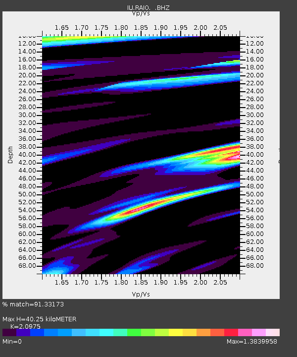
| Estimated Moho Depth: |
40.25 km |
| Estimated Crust Vp/Vs: |
2.10 |
| Assumed Crust Vp: |
6.566 km/s |
| Estimated Crust Vs: |
3.13 km/s |
| Estimated Crust Poisson's Ratio: |
0.35 |
|
| Radial Match: |
91.33173 % |
| Radial Bump: |
400 |
| Transverse Match: |
88.29863 % |
| Transverse Bump: |
400 |
| SOD ConfigId: |
4480 |
| Insert Time: |
2010-03-02 14:37:10.386 +0000 |
| GWidth: |
2.5 |
| Max Bumps: |
400 |
| Tol: |
0.001 |
|

Signal To Noise
| Channel | StoN | STA | LTA |
| IU:RAIO: :BHZ:19971028T06:25:13.063Z | 16.693151 | 5.208904E-6 | 3.1203837E-7 |
| IU:RAIO: :BHN:19971028T06:25:13.063Z | 2.1010675 | 1.0094997E-6 | 4.804699E-7 |
| IU:RAIO: :BHE:19971028T06:25:13.063Z | 3.9826207 | 1.2849699E-6 | 3.226443E-7 |
| Arrivals |
| Ps | 7.0 SECOND |
| PpPs | 18 SECOND |
| PsPs/PpSs | 25 SECOND |


