You are here: Home > Network List > ND - New CaleDonia Broadband Seismic Network Stations List
> Station KOUNC Koumac, New Caledonia > Earthquake Result Viewer
KOUNC Koumac, New Caledonia - Earthquake Result Viewer
| Earthquake location: |
Banda Sea |
| Earthquake latitude/longitude: |
-6.1/130.5 |
| Earthquake time(UTC): |
2014/12/06 (340) 22:05:10 GMT |
| Earthquake Depth: |
117 km |
| Earthquake Magnitude: |
6.0 MB |
| Earthquake Catalog/Contributor: |
NEIC PDE/NEIC COMCAT |
|
| Network: |
ND New CaleDonia Broadband Seismic Network |
| Station: |
KOUNC Koumac, New Caledonia |
| Lat/Lon: |
20.55 S/164.29 E |
| Elevation: |
88 m |
|
| Distance: |
35.8 deg |
| Az: |
116.901 deg |
| Baz: |
288.868 deg |
| Ray Param: |
0.07664545 |
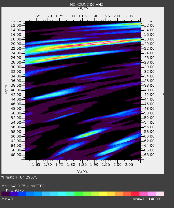
| Estimated Moho Depth: |
19.25 km |
| Estimated Crust Vp/Vs: |
1.94 |
| Assumed Crust Vp: |
5.14 km/s |
| Estimated Crust Vs: |
2.653 km/s |
| Estimated Crust Poisson's Ratio: |
0.32 |
|
| Radial Match: |
84.29573 % |
| Radial Bump: |
400 |
| Transverse Match: |
73.03565 % |
| Transverse Bump: |
400 |
| SOD ConfigId: |
822622 |
| Insert Time: |
2014-12-20 22:28:57.609 +0000 |
| GWidth: |
2.5 |
| Max Bumps: |
400 |
| Tol: |
0.001 |
|
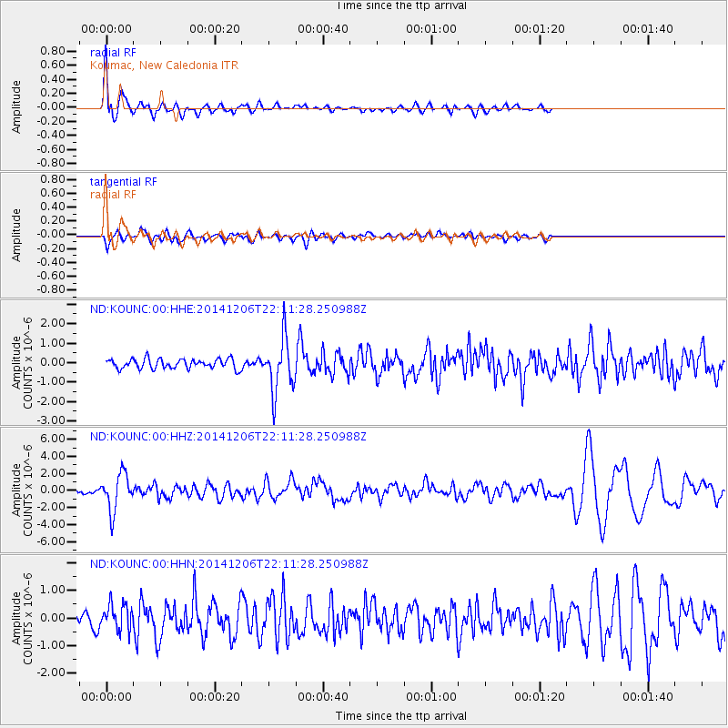
Signal To Noise
| Channel | StoN | STA | LTA |
| ND:KOUNC:00:HHZ:20141206T22:11:28.250988Z | 7.9790754 | 2.1949465E-6 | 2.750878E-7 |
| ND:KOUNC:00:HHN:20141206T22:11:28.250988Z | 2.1515236 | 4.73967E-7 | 2.2029366E-7 |
| ND:KOUNC:00:HHE:20141206T22:11:28.250988Z | 5.5267544 | 1.3592929E-6 | 2.4594777E-7 |
| Arrivals |
| Ps | 3.7 SECOND |
| PpPs | 11 SECOND |
| PsPs/PpSs | 14 SECOND |


