You are here: Home > Network List > RV - Regional Alberta Seismic Observatory for Earthquake Studies Network Stations List
> Station HSPGA Hill Springs, AB > Earthquake Result Viewer
HSPGA Hill Springs, AB - Earthquake Result Viewer
| Earthquake location: |
Near East Coast Of Honshu, Japan |
| Earthquake latitude/longitude: |
38.9/142.0 |
| Earthquake time(UTC): |
2015/05/12 (132) 21:12:58 GMT |
| Earthquake Depth: |
39 km |
| Earthquake Magnitude: |
6.8 MWP, 6.8 MI |
| Earthquake Catalog/Contributor: |
NEIC PDE/NEIC COMCAT |
|
| Network: |
RV Regional Alberta Seismic Observatory for Earthquake Studies Network |
| Station: |
HSPGA Hill Springs, AB |
| Lat/Lon: |
49.36 N/113.65 W |
| Elevation: |
1155 m |
|
| Distance: |
69.7 deg |
| Az: |
42.495 deg |
| Baz: |
306.277 deg |
| Ray Param: |
0.05541178 |
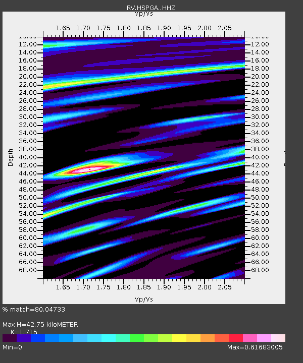
| Estimated Moho Depth: |
42.75 km |
| Estimated Crust Vp/Vs: |
1.72 |
| Assumed Crust Vp: |
6.178 km/s |
| Estimated Crust Vs: |
3.602 km/s |
| Estimated Crust Poisson's Ratio: |
0.24 |
|
| Radial Match: |
80.04733 % |
| Radial Bump: |
400 |
| Transverse Match: |
68.36458 % |
| Transverse Bump: |
400 |
| SOD ConfigId: |
7422571 |
| Insert Time: |
2019-04-18 20:49:09.582 +0000 |
| GWidth: |
2.5 |
| Max Bumps: |
400 |
| Tol: |
0.001 |
|

Signal To Noise
| Channel | StoN | STA | LTA |
| RV:HSPGA: :HHZ:20150512T21:23:33.43999Z | 10.486855 | 1.2187503E-6 | 1.1621696E-7 |
| RV:HSPGA: :HHN:20150512T21:23:33.43999Z | 1.9133856 | 4.0879436E-7 | 2.1364974E-7 |
| RV:HSPGA: :HHE:20150512T21:23:33.43999Z | 1.3905625 | 2.8104708E-7 | 2.0211036E-7 |
| Arrivals |
| Ps | 5.1 SECOND |
| PpPs | 18 SECOND |
| PsPs/PpSs | 23 SECOND |


