You are here: Home > Network List > TA - USArray Transportable Network (new EarthScope stations) Stations List
> Station I23K Minto, Yukon-Koyukuk, AK, USA > Earthquake Result Viewer
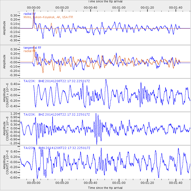
I23K Minto, Yukon-Koyukuk, AK, USA - Earthquake Result Viewer
*The percent match for this event was below the threshold and hence no stack was calculated.
| Earthquake location: |
Banda Sea |
| Earthquake latitude/longitude: |
-6.1/130.5 |
| Earthquake time(UTC): |
2014/12/06 (340) 22:05:10 GMT |
| Earthquake Depth: |
117 km |
| Earthquake Magnitude: |
6.0 MB |
| Earthquake Catalog/Contributor: |
NEIC PDE/NEIC COMCAT |
|
| Network: |
TA USArray Transportable Network (new EarthScope stations) |
| Station: |
I23K Minto, Yukon-Koyukuk, AK, USA |
| Lat/Lon: |
65.15 N/149.36 W |
| Elevation: |
149 m |
|
| Distance: |
91.4 deg |
| Az: |
24.615 deg |
| Baz: |
258.532 deg |
| Ray Param: |
$rayparam |
*The percent match for this event was below the threshold and hence was not used in the summary stack. |
|
| Radial Match: |
56.337486 % |
| Radial Bump: |
400 |
| Transverse Match: |
60.30728 % |
| Transverse Bump: |
400 |
| SOD ConfigId: |
822622 |
| Insert Time: |
2014-12-20 22:31:02.038 +0000 |
| GWidth: |
2.5 |
| Max Bumps: |
400 |
| Tol: |
0.001 |
|
Signal To Noise
| Channel | StoN | STA | LTA |
| TA:I23K: :BHZ:20141206T22:17:32.225017Z | 1.8921977 | 5.232205E-7 | 2.765147E-7 |
| TA:I23K: :BHN:20141206T22:17:32.225017Z | 1.2912071 | 3.5843198E-7 | 2.775945E-7 |
| TA:I23K: :BHE:20141206T22:17:32.225017Z | 0.7365154 | 1.6639062E-7 | 2.25916E-7 |
| Arrivals |
| Ps | |
| PpPs | |
| PsPs/PpSs | |


