You are here: Home > Network List > TJ - Tajikistan National Seismic Network Stations List
> Station GARM Garm, Tajikistan > Earthquake Result Viewer
GARM Garm, Tajikistan - Earthquake Result Viewer
| Earthquake location: |
Banda Sea |
| Earthquake latitude/longitude: |
-6.1/130.5 |
| Earthquake time(UTC): |
2014/12/06 (340) 22:05:10 GMT |
| Earthquake Depth: |
117 km |
| Earthquake Magnitude: |
6.0 MB |
| Earthquake Catalog/Contributor: |
NEIC PDE/NEIC COMCAT |
|
| Network: |
TJ Tajikistan National Seismic Network |
| Station: |
GARM Garm, Tajikistan |
| Lat/Lon: |
39.00 N/70.32 E |
| Elevation: |
1305 m |
|
| Distance: |
71.4 deg |
| Az: |
314.503 deg |
| Baz: |
114.474 deg |
| Ray Param: |
0.054060686 |
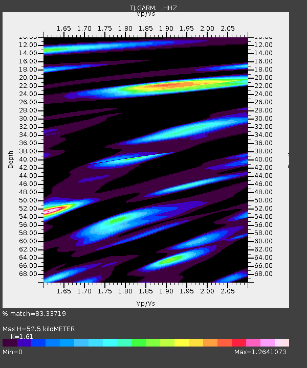
| Estimated Moho Depth: |
52.5 km |
| Estimated Crust Vp/Vs: |
1.61 |
| Assumed Crust Vp: |
6.306 km/s |
| Estimated Crust Vs: |
3.917 km/s |
| Estimated Crust Poisson's Ratio: |
0.19 |
|
| Radial Match: |
83.33719 % |
| Radial Bump: |
400 |
| Transverse Match: |
72.28434 % |
| Transverse Bump: |
400 |
| SOD ConfigId: |
822622 |
| Insert Time: |
2014-12-20 22:31:10.100 +0000 |
| GWidth: |
2.5 |
| Max Bumps: |
400 |
| Tol: |
0.001 |
|

Signal To Noise
| Channel | StoN | STA | LTA |
| TJ:GARM: :HHZ:20141206T22:15:47.230022Z | 18.838959 | 5.351029E-6 | 2.840406E-7 |
| TJ:GARM: :HHN:20141206T22:15:47.230022Z | 3.2468307 | 1.111933E-6 | 3.4246722E-7 |
| TJ:GARM: :HHE:20141206T22:15:47.230022Z | 8.300764 | 1.9259028E-6 | 2.3201514E-7 |
| Arrivals |
| Ps | 5.3 SECOND |
| PpPs | 21 SECOND |
| PsPs/PpSs | 26 SECOND |


